Catalog Archive
Auction 125, Lot 772

"Plan du Port et de la Ville de Nangasaki", Bellin, Jacques Nicolas

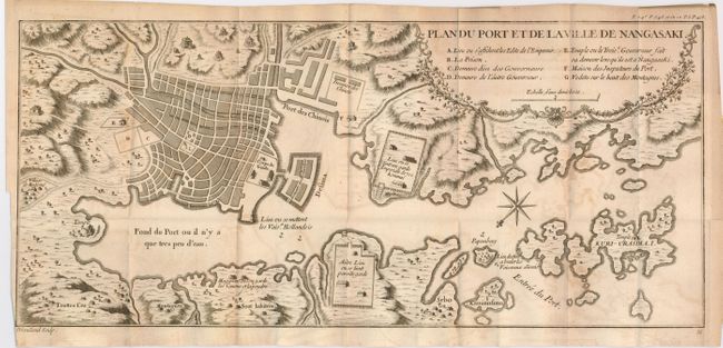
Subject: Nagasaki, Japan

Period: 1736 (circa)

Publication: Charlevoix's Histoire et Description Generale du Japon

Color: Black & White

Size:
17.7 x 7.9 inches
45 x 20.1 cm
Download High Resolution Image
(or just click on image to launch the Zoom viewer)

Bellin based this map of Nagasaki on the Kaempfer/Scheuchzer map for the History of Japan, which first appeared in 1727. The map is oriented to the southwest and locates principal points of interest and major buildings. The Deshima is central to the map. This was an artificial island in the bay of Nagasaki where the VOC (Dutch East India Company) were allowed to trade with the representatives of the Shogun in Edo. A floral style title cartouche incorporates the key. Engraved by Guillhaume Dheulland.

References: Walter #100.

Condition: B+

Dark impression on thick hand laid paper with full margins. Folding as issued with some offsetting.

Estimate: $300 - $400

Sold for: $180

Closed on 9/24/2008

Archived