Catalog Archive
Auction 125, Lot 365

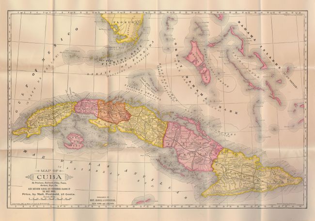
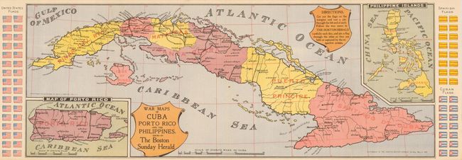
"[Lot of 2] Map of Cuba Its Provinces, Railroads, Cities, Towns, Harbors, Bays, Etc. also Southern Florida and Neighboring Islands of the West Indies [and] War Maps of Cuba Porto Rico and the Philippines",

Subject: Cuba

Period: 1897-1898 (published)

Publication:

Color: Printed Color

Size:
See Description
Download High Resolution Image
(or just click on image to launch the Zoom viewer)

The first is nice pocket map (19 x 12.5") that folds into paper covers titled "Map and History of Cuba from the Latest and Best Authorities, Including a Clear and Graphic Account of the War of 1895-1897." The map is nicely colored by province with good detail throughout. Extends to the Bahama Islands and southern Florida. The covers include a 28-page booklet on the Spanish American War and the history of Cuba. A beautiful example that has just a couple tiny fold intersection splits, else fine. (A)

The second map (25.3 x 9.5") was published as a supplement to The Boston Herald, Sunday, May 8, 1898. Little flags at sides for Cuba, Spain and the United States were meant to be cut out and stuck to the map to indicate cities held or captured as the reader "follows the war news in The Boston Herald." Inset of Porto Rico and another of the Philippine Islands. Folding as issued and mint. (A+)

References:

Condition:

See descriptions.

Estimate: $120 - $140

Sold for: $90

Closed on 9/24/2008

Archived