Catalog Archive
Auction 125, Lot 226

"Map Showing the Distribution of the Tribes of Alaska and Adjoining Territory…", U.S. Coast Survey
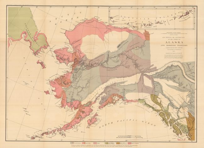
Subject: Alaska

Period: 1875 (dated)

Publication: Contributions to North American Ethnology 1875

Color: Printed Color

Size:
30.8 x 22 inches
78.2 x 55.9 cm
Download High Resolution Image
(or just click on image to launch the Zoom viewer)

This large and colorful ethnologic map focuses on the Native American tribes of Alaska, the Siberian Peninsula, and part of today's Yukon Territory. Color overprinting and line locate the territories of the six tribal groups in Alaska, and part of British Columbia: Tinneh Indians; Innuit tribes; Aleuts; Asia Chukhis American Tlinkets; Nasse and Chimsyan Indians; and Haida or Kygahni. Individual tribes are named with the groups. Compiled by W.H. Dall, U.S. Coast Survey with the geographical data brought up to November 1875. Large inset at upper right continues the Aleutian Islands. Published by the Bureau of Ethnology, a short lived agency, that was renamed the American Bureau of Ethnology in 1897 and eventually merged with the Smithsonian Institution in 1965. An uncommon map we've not previously encountered.

References:

Condition: A+

Folding as issued. Bright, strong coloring, full margins. Two fold intersections have tiny splits with very small bit of archival tape on verso, still fine for a map of this size.

Estimate: $200 - $300

Sold for: $210

Closed on 9/24/2008

Archived