Catalog Archive
Auction 125, Lot 224

"Map of the Navajo Indian Reservation", U.S. Bureau of Indian Affairs

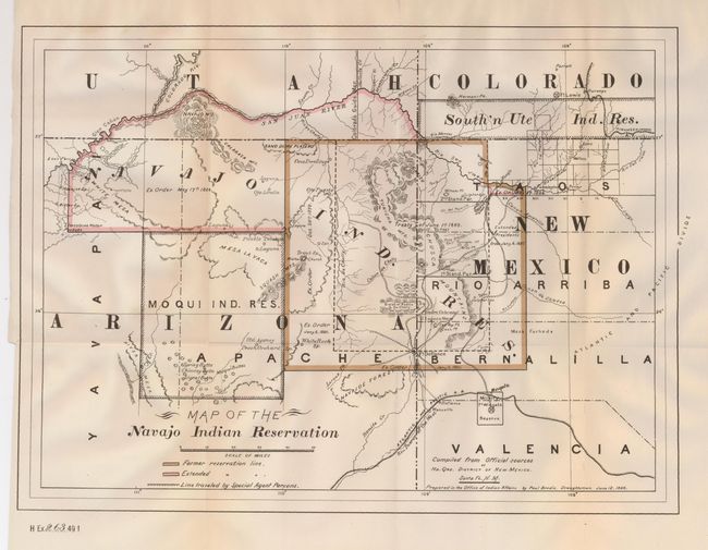
Subject: Southwestern United States

Period: 1886 (dated)

Publication: H Ex 263, 49th Congress, 1st Session

Color: Printed Color

Size:
15.2 x 11.3 inches
38.6 x 28.7 cm
Download High Resolution Image
(or just click on image to launch the Zoom viewer)

This is a very detailed map of the Navajo Indian Reservation that shows an expansion of the reservation north of the Hopi Reservation and into southeastern Utah. There is interesting detail including cave dwellings, the Divide of Puerco & De Chelly, changes in boundaries with details, and more. Creeks, rivers, canyons, valleys, mountains, mesas, villages, lakes and passes are shown. The map locates and names the Hopi Mesas ("Buttes") Canyon de Chelly, Fort Defiance and Wingate, Laguna (Pueblo), Walker Church, White Rock Springs, the Crossing of the Fathers, and much more. The route traveled by Special Agent Parsons is illustrated. It is interesting to note that the lands gained in Utah are noted as removed by Executive Order on the 1892 edition of this map. In Colorado the Southern Ute Indian Reservation is located, as is Durango and a portion of the Denver & Rio Grande RR.

References:

Condition: A

Issued folding, now pressed. Crisp, sharp impression and coloring. Hint of toning a fold, otherwise fine.

Estimate: $120 - $160

Sold for: $180

Closed on 9/24/2008

Archived