Catalog Archive
Auction 125, Lot 193

"[A Map of the Rapids of the Ohio River, and of the Counties on each side thereof, so far, as to include the routes contemplated for Canal Navigation]", U.S. Government

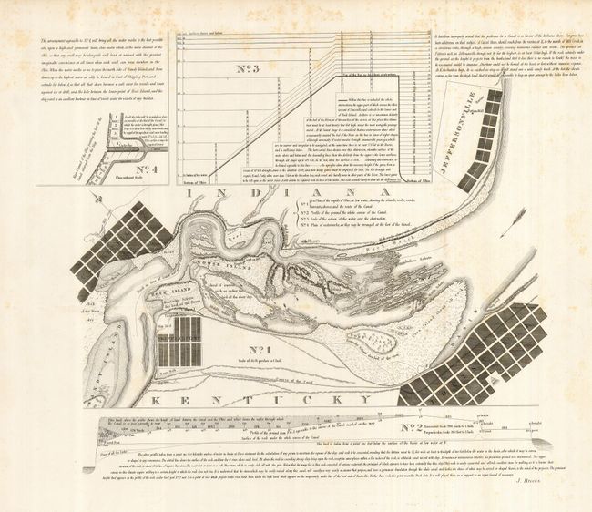
Subject: Indiana, Kentucky; Ohio River

Period: 1834 (published)

Publication: American State Papers

Color: Black & White

Size:
20 x 16.5 inches
50.8 x 41.9 cm
Download High Resolution Image
(or just click on image to launch the Zoom viewer)

This map from Volume I of the ASP is a reissue of Brook's 1806 map that details the difficulties and plans to open this section of the river for navigation. This portion of the river is known as the Falls of the Ohio and drops 24 feet in a short distance, a major obstacle to early navigation. On this finely engraved map the river, rapids and obstacles to navigation are shown in great detail. Likewise detailed engineering plans are noted. The map shows the course of the Ohio through Clarkesville, Shippingport, Louisville and Jeffersonville. Each city's street plan is shown in grid pattern and the capital building in Louisville is located. The proposed canal is shown. Locates Corn Island, Goose Island, Rock Island, the Great Reefs of Goose Island, and more. On the uncommon scale of 55-55/100 perches to the inch. The Louisville & Portland Canal was completed in 1830, providing a bypass around the falls and opening the way for increased river traffic from Pittsburgh to New Orleans. The title is taken from Fitch's catalog #53 description which extrapolates the title from Brook's earlier map. A rare issue.

References:

Condition: B+

Folding with some tape closures on verso to fold intersection splits. Short tear at binding trim. A little light scattered foxing mostly at upper right, still a very nice example.

Estimate: $200 - $250

Unsold

Closed on 9/24/2008

Archived