Catalog Archive
Auction 125, Lot 165

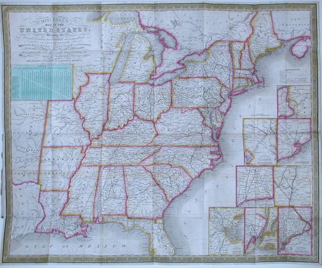
"Mitchell's Map of the United States; Showing the Principal Traveling, Turnpike and Common Roads…Throughout the Country, Carefully Compiled from the Best Authorities", Mitchell, Samuel Augustus

Subject: Eastern United States

Period: 1835 (dated)

Publication:

Color: Hand Color

Size:
22 x 18.5 inches
55.9 x 47 cm
Download High Resolution Image
(or just click on image to launch the Zoom viewer)

This scarce pocket map shows the United States west to the Mississippi River and a little beyond to include parts of Texas and Missouri Territory. It is very detailed and features eight insets; the Environs of Philadelphia, Baltimore and Washington, Charleston, Boston, New York, Albany, Hartford and New Haven, and the Vicinity of the Falls of Niagara. The labyrinth of canals and early railroads are clearly shown and finely colored. As a traveler's map, it features a detailed table which lists the distance between twenty-five cities. Mitchell's early series of maps, first published in 1832, was designed for the market represented by the burgeoning number of travelers and new immigrants. The maps were printed on thin bank note paper and folded so they could be carried easily for quick reference while traveling. Embellished with keyboard-style border and fancy titling. This map, dated 1835 in the title, folds into original green cloth embossed and gilt covers. Complete with the 84 page index to the map that lists railroads, steamboat, stagecoach, and railroad routes, and more. The cover is titled Mitchell's Compendium of Canals & Railroads.

References:

Condition: B+

The folding map has fine original color and early impression with a couple areas of offsetting visible in blank area. The spine is missing resulting in back cover separation. Booklet pages with occasional scattered foxing. Covers with a little scuffing.

Estimate: $750 - $850

Sold for: $650

Closed on 9/24/2008

Archived