"North America", Philip, George
Subject: North America
Period: 1852 (dated)
Publication:
Color: Hand Color
Size:
24 x 19.8 inches
61 x 50.3 cm
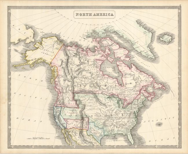
The United States and Great Britain established in 1818 joint claim over the Oregon Territory - the region north of Spanish controlled Upper California up to the southern boundary of Russia's Alaska Territory at North latitude 54°40'. By the late 1830's this arrangement was beginning to fall apart.
In the 1840's the expansionist Democrats, including their 1844 presidential candidate, James Polk, claimed the entire region for the United States. Their expansionist desires were expressed by Polk's famous campaign slogan, "Fifty-four Forty or Fight!" The slogan also became a rally cry for Americans desiring to settle the territory. Following Polk's election, the dispute was resolved by the 1846 Treaty of Oregon, which struck a compromise that fixed the U.S./Canadian boundary at 49º North.
A very unusual map of North America showing the entire Oregon Territory as part of British America, despite the forlorn dashed line on the actual border noting that it was the boundary as settled in 1846. This border is ignored in favor of the second dashed border consigning the territory to British America. Texas is shown with a rather truncated western border, and the New Mexico Territory fills the land between it and California. The southern border is pre-Gadsden Purchase, with the Gila River as the boundary with Mexico. California is named as New California, and a Mormon settlement is noted in the large Utah Territory near the Salt Lake, just below an outpost for the American Fur Company.
References: Wheat (TMW) #759; Wheat (Gold) #229.
Condition: A
Nice original color on a sound sheet with some faint marginal spots, not affecting the map.