"Carte Generale de l'Amerique Septentrionale, et des Iles qui es Dependent", Brue, Adrien Hubert
Subject: North America
Period: 1838 (dated)
Publication:
Color: Hand Color
Size:
20.3 x 14.5 inches
51.6 x 36.8 cm
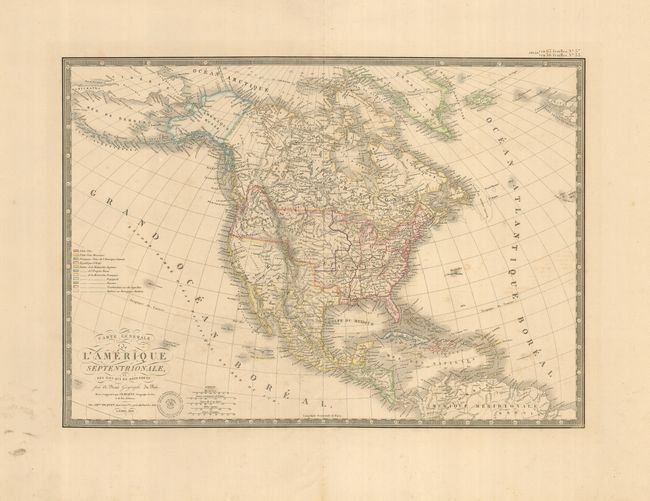
The United States and Great Britain established in 1818 joint claim over the Oregon Territory - the region north of Spanish controlled Upper California up to the southern boundary of Russia's Alaska Territory at North latitude 54°40'. By the late 1830's this arrangement was beginning to fall apart.
In the 1840's the expansionist Democrats, including their 1844 presidential candidate, James Polk, claimed the entire region for the United States. Their expansionist desires were expressed by Polk's famous campaign slogan, "Fifty-four Forty or Fight!" The slogan also became a rally cry for Americans desiring to settle the territory. Following Polk's election, the dispute was resolved by the 1846 Treaty of Oregon, which struck a compromise that fixed the U.S./Canadian boundary at 49º North.
Excellent map of North America and the West Indies. Beautifully engraved on fine heavy paper with the embossed atlas seal of the publisher below the script title. Alaska is named as Amerique Russe and is still a bit misshapen. The United States is shown with the northern border of Oregon Territory bulging upward well into Canada, reflecting the United States claims in that region. The individual state and territorial borders are shown up to the Mississippi River, with a large Arkansas Territory extending above Texas, which is still shown as a part of Mexico. The map is surrounded in a decorative keyboard border.
References:
Condition: B+
Nice original color on a sturdy sheet with wide margins. There is some faint foxing and marginal soil.