Catalog Archive
Auction 124, Lot 602

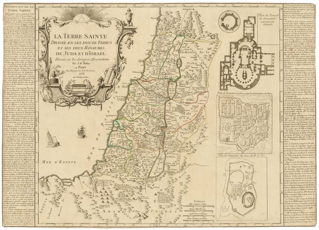
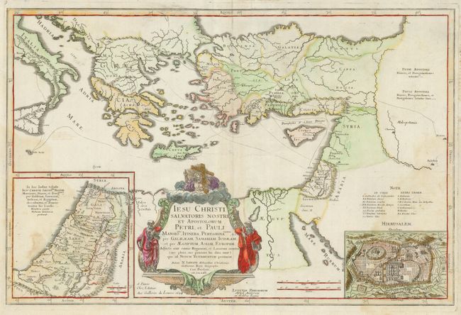
"[Lot of 2] La Terre Sainte Divisee en ses Douze Tribus et ses Deux Royaumes de Juda et d'Israel [and] Iesu Christi Salvatoris Nostri et Apostolorum Petri, et Pauli…",

Subject: Holy Land

Period: 1699-1756 (circa)

Publication:

Color: Hand Color

Size:
See Description
Download High Resolution Image
(or just click on image to launch the Zoom viewer)

An attractive pair of maps by French mapmakers depicting the Holy Land.

1) La Terre Sainte Divisee en ses Douze Tribus et ses Deux Royaumes de Juda et d'Israel by Jean Baptiste Nolin, dated 1756. This map depicts Palestine on both sides of the Jordan divided among the Tribes of Israel. There are three inset plans: Plan du Temple de Jerusalem construit par Solomon; Plan de Jerusalem moderne sous la domination des Turcs; Plan de Jerusalem du tems de N.S.J.C. Two panels of French text flank the map. It has original outline color on a strong sheet, trimmed to the neatlines. The map is backed with tissue for no apparent reason (25.8 x 18.4").
2) Iesu Christi Salvatoris Nostri et Apostolorum Petri, et Pauli… is a boldly engraved map that details the travels of St. Peter and St. Paul throughout the Eastern Mediterranean. There are two large and detailed insets, one of Jerusalem (Hierusalem Occidens) and another of the travels of Jesus (In hac Iudaa tabula Iesu Christi Salvatris...) The decorative cartouche features Jesus carrying the cross with St. Peter and St. Paul at the sides. This map is by Nicholas Sanson, dated 1699. Tear into map (7.5") repaired with paper on verso. Light stains on right and left side, still a map that would frame very well. Couple of paper repairs and reinforcements on verso (22 x 14.6").

References: Map 1) Laor #697; Map 2) Laor #536.

Condition: B

See descriptions.

Estimate: $250 - $300

Sold for: $180

Closed on 5/7/2008

Archived