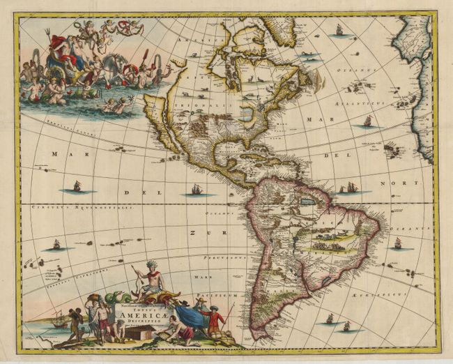
"Novissima et Accuratissima Totius Americae Descriptio", Meurs, Jacob van
Subject: Western Hemisphere
Period: 1673 (circa)
Publication: Die Unbekante Neue Welt , oder Beschreibung des Welt-teils Amerika
Color: Hand Color
Size:
21 x 16.8 inches
53.3 x 42.7 cm
Uncommon and exceptionally decorative map of the Americas based largely on Visscher's map of 1658. California is shown as a large island after Henry Brigg's map with the Pacific coastline continuing northeast toward the Straet Anian, which separates it from Anian. The interior is lacking any of the recent French discoveries and there is one huge, open-ended, Great Lake and a confused system of rivers in the Mississippi valley. In the Southwest, the Rio del Norto flows from a large interior lake and empties into the sea between the mainland and California. In South America, Parime Lacus is prominent. The most outstanding features of the map are the beautifully engraved decorative details that include numerous vignettes of wildlife, Indian battles, sailing ships and two large cartouches. At bottom, the title is surrounded by Native Americans trading with Europeans and filling the North Pacific is a lavish scene of Neptune and his consort in a chariot surrounded by his entourage and putti.
References: Burden (II) #430; McLaughlin #50; Tooley (AM) #36, plt. 43.
Condition: B
A dark impression on a sheet issued folding, now flattened. The map has a neatly repaired tear from just above 'Atlanticus' to just south of Cape Verde on the African coast. There are some repaired areas of loss on the fold intersections. The map presents quite well and the condition is usual for this issue that was published in folded format.