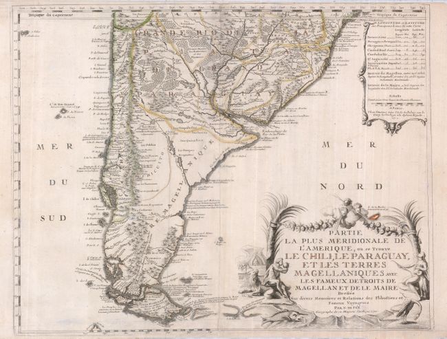
"Partie la Plus Meridionale de l'Amerique, ou se Trouve le Chili, le Paraguay, et les Terres Magellaniques avec les Fameux Detroits de Magellan et de la Maire", Fer, Nicolas de
Subject: South America - Southern
Period: 1720 (dated)
Publication:
Color: Hand Color
Size:
25 x 19.5 inches
63.5 x 49.5 cm
A richly detailed map of the southern tip of South America, from about the Tropic of Capricorn south to Tierra del Fuego. Off the eastern coast lies the phantom Pepys Island, here called I. Pepie ou Peipis. Pepys Island was named for Samuel Pepys by Ambrose Cowley in 1684, who placed it a couple hundred miles north of the Falkland Islands. Many expeditions attempted to locate the island and it is assumed to be a misplaced member of the Falkland Islands. The title is surrounded by natives, animals and wind heads, and an inset at the upper right lists latitude and longitude for the principal areas.
References:
Condition: B
A good impression on a sheet with faded original outline color. There is paper added to the right bottom margin to facilitate framing. The centerfold and a couple of creases are reinforced with tissue on the verso. Top margin trimmed nearly to the neatline, which has been reinstated in a few areas around the map.