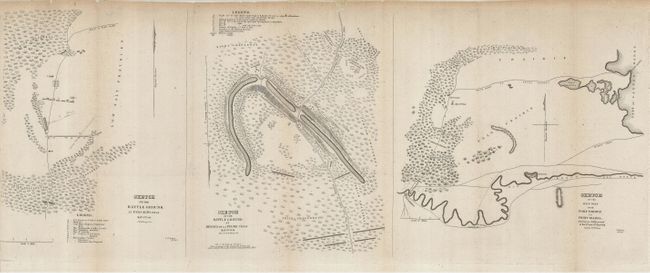
"Sketch of the Battle Ground at Palo Alto Texas. May 8th 1846. / Sketch of the Battle Ground at Resaca de la Palma Texas May 9th 1846. / Sketch of the Main Road from Fort Brown to Point Isabel, Showing the Battle ground of the 8th and 9th May 1846.", U.S. War Department
Subject: Texas, Mexican-American War
Period: 1846 (published)
Publication: Message from the President of the United States… General Zachary Taylor
Color: Black & White
Size:
28.5 x 11 inches
72.4 x 27.9 cm
These maps show the areas of the first battles between Mexican and American forces that led to the formal declaration of war on May 13th, 1846. Texas had officially been admitted to the Union in 1846; however Mexico did not recognize the United States' claims on Texas and considered it a rebelling province. The hostilities had been building since the April 24th Thornton Affair, in which a 63-man patrol sent to reinforce U.S. claims in the area was attacked by a 2000-strong Mexican cavalry. General Zachary Taylor came with 2400 troops to relieve the forces at the makeshift U.S. fort, later named Fort Brown. On May 8, General Arista intercepted Taylor's force with a 3400-man army and the hostilities began in earnest with battles at Palo Alto and Resaca de Palma. These maps were from the first reports of the battles.
References:
Condition: B+
Originally folded, now presented to show the three maps on one tissue-backed sheet. There is some minor loss at the top of the sheet and on the left binding side, still quite good for a map of this type.