"Texas", Flemming, Carl
Subject: Texas
Period: 1843 (circa)
Publication:
Color: Hand Color
Size:
12.5 x 15.6 inches
31.8 x 39.6 cm
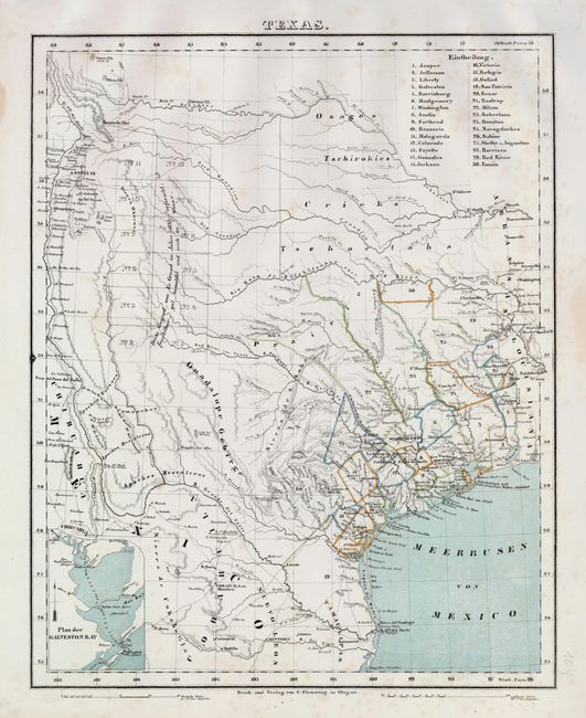
The Republic of Texas was a sovereign state in North America from 1836 to 1845. It was formed as a break-away republic from Mexico by the Texas Revolution. The nation claimed a large region that included all of the present state of Texas together with part of the former Mexican region of New Mexico (parts of present-day New Mexico, Oklahoma, Kansas, Colorado, and Wyoming). The eastern boundary with the United States was defined by the Adams-Onís Treaty between the United States and Spain, in 1819. Its southern and western-most boundary with Mexico was under dispute throughout the existence of the republic, with Texas claiming that the boundary was the Rio Grande, and Mexico claiming the Nueces River as the boundary.
This scarce German map, a reduced version of Arrowsmith's 1841 Republic of Texas map, shows the extent of Texas's claims to the region of the upper Rio Grande, including Santa Fe, Taos and Albuquerque. The detailed map identifies many roads, rivers, towns, and forts. Thirty land districts are outlined and named in a table at the top right corner. The northern panhandle is divided into 12 sections, with the German notation (copied from Arrowsmith) that the land was well wooded and watered. Inset with a small map of Galveston Bay in the lower left. The outline color on this example delineates only the counties; the republic boundaries are shown by line only.
References:
Condition: B+
A few spots of foxing, still an attractive example. It has original outline color, with printed color for the water.