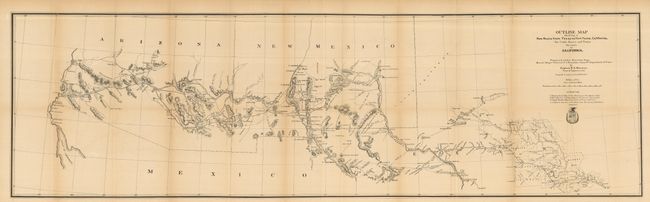
"Outline Map Showing a New Route from Texas to Ft. Yuma, California, for Cattle Droves and Trains en Route to California", U.S. Army
Subject: Southwestern United States
Period: 1880 (published)
Publication: HR ex doc 1, 46th Congress 3rd Session
Color: Black & White
Size:
49 x 14.3 inches
124.5 x 36.3 cm
Title continues "Prepared under direction from Brevet Major General J.J. Reynolds, Commdg. Department of Texas." This unusual map, created by Capt. O.C. Overman, begins in Austin and shows in great detail the route to Fort Yuma, Arizona Territory. The route travels though numerous Army forts along the way: Cocho, Stockton, Quickman, Bliss, Selder, Commings, and the famous Ft. Bowie. It also passes though Maricopa Village and Wells and the Pima Villages, the site of today's Phoenix. There is remarkable detail of water holes, springs, grazing areas, missions, camps, Indian villages, and mines. The map lists four authorities including Gillespie's Map of Texas (1867) and Gildart's Journal. Complete with the original 574-page Congressional report, hardbound in brown cloth with the title gilt-stamped on the spine. The map's cartography is circa 1867, but was published in this 1880 report.
References: Wheat (TMW) #1216.
Condition: B+
The map folds as issued, and is loose from the book. A couple minor marginal fold splits closed with archival tape on verso. The left binding side has a closed 1.5" tear into the map. The book is faded with shelf wear, contents are very nice less a little looseness in a couple signatures.