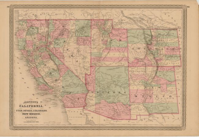
"Johnson's California, also Utah, Nevada, Colorado, New Mexico, and Arizona", Johnson, A. J.
Subject: Southwestern United States
Period: 1870 (circa)
Publication: Illustrated Family Atlas
Color: Hand Color
Size:
23.5 x 17 inches
59.7 x 43.2 cm
Johnson's series of maps of the American Southwest is one of the most interesting progressions in 19th century American cartography. The series was produced during a time of rapid westward expansion and changes in territorial boundaries. This map, copyright dated 1864 but published circa 1870, is one of the later editions in the series. It is from a completely new plate with a newly designed decorative border. It displays many changes in watershed and topography with several of the earlier notations removed and new notations inserted. Nevada has the addition of Elko and White Pine Counties, Arizona still has the original four counties, and the Pacific Railroad is shown completed through Utah. There is extensive detail of the U.S. Mail routes, the emigrant roads, proposed southern railroad routes, and exploration routes. The Pony Express route was shown on earlier editions, but is not present on this map. There are numerous notations of gold and silver mines and much else of interest.
References:
Condition: B+
A few unobtrusive spots, light toning along centerfold, and several short edge tears not reaching the neatline. Overall a very good example.