Catalog Archive
Auction 124, Lot 187

"Map No. 2 From the Rio Grande to the Pacific Ocean…", Whipple, Amiel Weekes

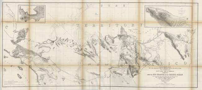
Subject: Southwestern United States

Period: 1853-54 (dated)

Publication: U.S. Pacific Railroad Surveys

Color: Black & White

Size:
50.5 x 21.8 inches
128.3 x 55.4 cm
Download High Resolution Image
(or just click on image to launch the Zoom viewer)

During the 1850s, the U.S. government sponsored an extensive series of expeditions designed to gather information on the vast new territories that had been acquired in western North America. The discovery of gold in California further stimulated westward traffic and heightened the need for a faster and more convenient way to bring the far-flung parts of the country together. In 1853 Congress commissioned the Army's Topographic Bureau to conduct a series of surveys to find a suitable route for a transcontinental railroad. There were six major expeditions; five of them covered the area between the Great Plains and west coast, and the sixth explored the coastal states of California and Oregon. All of these expeditions were accompanied by naturalists and artists to document the landscape, flora and fauna along the route. The reports, maps and lithographs were published in the 13 volume report "Explorations and Surveys to ascertain the most practicable and economical route for a Railroad from the Mississippi river to the Pacific Ocean."

An impressive, immense map that covers the railroad surveys between Albuquerque and Los Angeles, with the Gila River on the bottom. The map details the route from Isleta (on the Rio Grande) past Laguna through Campbell's Pass and down the Rio Puerco of the West across New Mexico Territory to Los Angeles. Topography and hydrography are shown in great detail. Zuni and Inscription Rock are shown on the trail of Lt. Beckwith in 1847. Insets: Sketches Aztec Pass & Campbell's Pass from Agua Azul to Salt Spring. This map is from the report on the route near the 35th parallel surveyed by Whipple and Ives.

References: Wheat (TMW) #875.

Condition: B

Folding, as issued. Some fold separations as is typical for these maps, some reinforced on the verso with archival tape. The upper left fold is separated about 5" into the map. There are a few spots of foxing.

Estimate: $250 - $300

Unsold

Closed on 5/7/2008

Archived