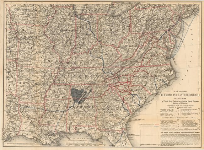
"Map of the Richmond and Danville Railroad System in Virginia, North Carolina, South Carolina, Georgia, Tennessee, Alabama and Mississippi", Colton, G.W. & C.B.
Subject: Southern United States
Period: 1883 (dated)
Publication:
Color: Printed Color
Size:
26 x 19 inches
66 x 48.3 cm
This very detailed railroad map extends to show the railroad network from the East Coast westward to include Louisiana, Arkansas, Missouri and most of Iowa. The railroad network is shown in red, with connecting lines in blue. Concentric circles, centered on Salisbury, North Carolina, extend outward at 100 mile intervals. The map includes a list of 19 railroads operated by the Richmond and Danville R.R., and controlled by the Richmond and West Point Terminal Railway and Warehouse Co. The Richmond and Danville Railroad was chartered in 1847 and completed to Danville in 1856. The map itself is very detailed with much information on place names, showing watershed, topography, coal fields, and counties. A large area in Alabama is over-colored in gray and labeled "Black Warrior Coal Fields" and to the east are the Coosa and Cababa fields. An extensive table below the title gives the total track mileage for each railroad and other information on the rail system. The map was created and printed by the G.W. & C.B. Colton company.
References:
Condition: A
Issued folding, now pressed and backed with archival tissue. The binding edge has been remargined to even the edge at the binding trim. A small section (1/4") of the border in the new margin has been replaced with facsimile. Some minor marginal chipping and a couple fold splits have been reinforced with the tissue on back.