Catalog Archive
Auction 124, Lot 136

"Carte Generale des Etats-Unis de l'Amerique Septentrionale, Renfermant Aussi quelques Provinces Angloises adjacentes…", Tardieu, Pierre Francois

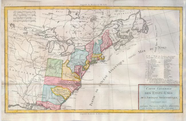
Subject: Eastern United States

Period: 1787 (published)

Publication: Lettres d'un Cultivateur Americain

Color: Hand Color

Size:
16.3 x 9.8 inches
41.4 x 24.9 cm
Download High Resolution Image
(or just click on image to launch the Zoom viewer)

An uncommon map of the early United States and one of the first printed maps to name Frankland. Also known as Franklinia, it is shown here just west of the border of North Carolina, named Pays de Frankland. In 1785, settlers in western North Carolina and what would become eastern Tennessee organized a state government to be named in honor of Benjamin Franklin. Congress turned down their appeal but the state maintained a legislature and governor until 1788. This ephemeral state appears on only a small number of maps. The 14th state of Vermont is named and noted in the key at right, with a notation in French that it was 'not yet accepted in the confederation'. Virginia is shown in a strange configuration and there is a square-shaped region denoted as Pays de Kentukey. This map was published by Michel Guillaume De Crevecoeur, a French-born surveyor, who settled in New York where he produced his classic collection of twelve essays that reflected on the nature of American life, particularly its customs and manners. His description of bountiful American lands spurred many French people to immigrate to America.

References: McCorkle #787.8; Mapforum 1, Checklist of Early Maps of the US #69; Baynton-Williams (TMC-72) #1.

Condition: B

Issued folding, now flattened with a fold separation in the lower third of the map reinforced on the verso with light tissue. Paper has been added to the right binding side to facilitate framing, with a small portion of neatline replaced in facsimile.

Estimate: $425 - $500

Sold for: $600

Closed on 5/7/2008

Archived