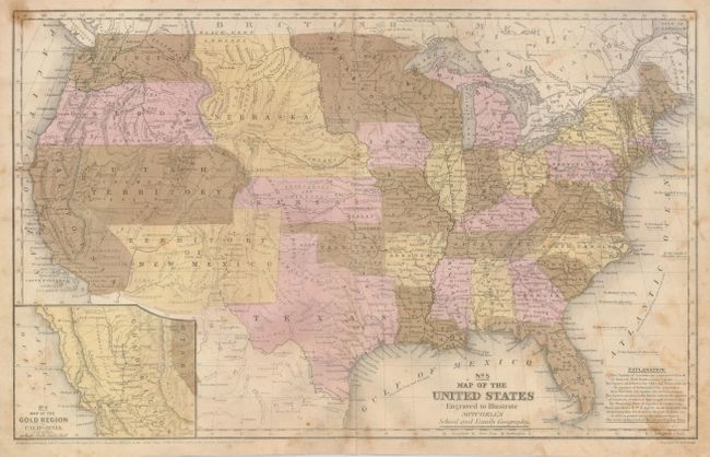
"No. 5 Map of the United States Engraved to Illustrate Mitchell's School and Family Geography", Mitchell, Samuel Augustus
Subject: United States
Period: 1852 (dated)
Publication: Mitchell's School and Family Geography
Color: Hand Color
Size:
16.8 x 10.5 inches
42.7 x 26.7 cm
This map has interesting western territorial borders including the important territorial acquisitions of the Mexican-American War and the newly completed Gadsden Purchase. Oregon and Washington territories extend to the Continental Divide in the Rocky Mountains. Utah Territory stretches from California to Kansas and Nebraska, and Nebraska is a huge territory occupying the land between Minnesota Territory, the Continental Divide, Canada and Kansas. The early depiction of New Mexico Territory occupies all of today's Arizona, as well as parts of Nevada and Colorado. The inset "No. 6 Map of the Gold Region of California" details the Gold Regions. It names Suttersville, Sacramento City, Auburn, Boston, Culloma, and all of the important gold settlements. Lake Tahoe appears map in an early representation as Bonpland Lake. The map bears the copyright date of 1852, but was not published until circa 1855.
References:
Condition: B
The map has some scattered foxing, principally near edges. The colors are a little oxidized as is often the case with these maps. A short, clean split at bottom is closed on verso. There are some pencil notations on verso that do not show to front.