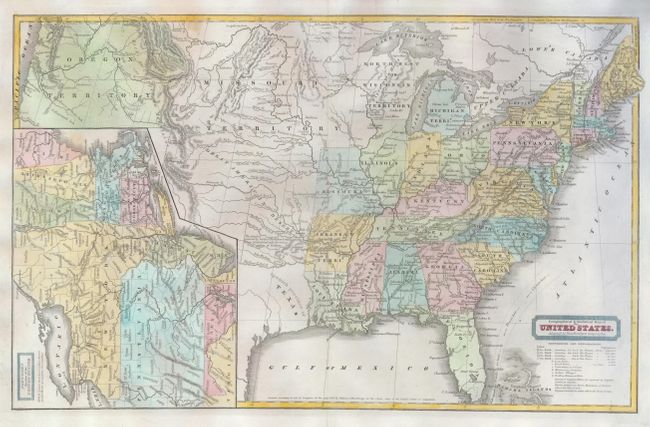
"Geographical & Statistical Map of the United States. Adapted to Woodbridge's Geography", Woodbridge, William Channing
Subject: United States
Period: 1831 (dated)
Publication:
Color: Hand Color
Size:
16.7 x 10.3 inches
42.4 x 26.2 cm
An interesting map showing a very transitional United States as it expands towards the Pacific Ocean in the middle of the 19th century. A detailed map of the northern United States is inset in the left of the main map. Michigan, Wisconsin and Arkansas are territories with the Upper Peninsula of Michigan belonging to Wisconsin. The large Missouri Territory extends to the Canadian border and west to the boundary of Oregon Territory that encompasses the present-day states of Oregon, Washington and Idaho. Texas is named as a Spanish province and a note above the Red River mentions that the desert is traversed by herds of Buffaloes & wild Horses & inhabited only by roving bands of Indians. A detailed key in the lower right notes various sizes of cities, universities, missionary stations, Indian villages, trading houses and forts.
References:
Condition: B+
Issued folding, now flattened and backed with tissue. There are a couple of minor printer's creases on the right side of the map and some faint irregular toning in the left of the map.