Catalog Archive
Auction 123, Lot 309

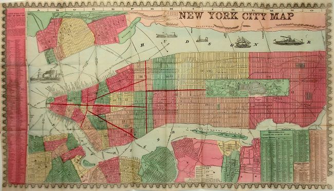
"New York City Map", Phelps, Humphrey

Subject: New York

Period: 1866 (published)

Publication:

Color: Hand Color

Size:
29 x 16 inches
73.7 x 40.6 cm
Download High Resolution Image
(or just click on image to launch the Zoom viewer)

Beautiful pocket-map of Manhattan including the nearby areas of Brooklyn and New Jersey, complete with original booklet titled, "The Great Metropolis. Phelps' New York City Guide to All that can be seen and How to see it." This plan of the city shows Central Park the same year that the Greensward Plan for its design was adopted, and presents a slightly different configuration that includes a prominent Cricket Ground. Street guides for New York and Brooklyn are contained in panels at side and bottom. The map is vividly colored by ward with fire districts and public buildings located. The railroads and ferry routes are well documented. The map is enclosed in a decorative border and includes several small vignettes of ships. Book in blue cloth covers with embossing and gilt lettering, 70 pp. Is filled with information on the city including an extensive street directory and numerous engraved views of buildings and sites. Frontispiece is a birds-eye-view of the city.

References: Haskell, #1047. Ref: Haskell, #1047.

Condition: A

Map is a lovely example on fine banknote paper. Short toned portion along one fold. Text pages are clean and bright, front endpaper is toned. The covers show a little soiling and the spine has a tiny chip.

Estimate: $450 - $550

Sold for: $375

Closed on 2/20/2008

Archived