Catalog Archive
Auction 123, Lot 304

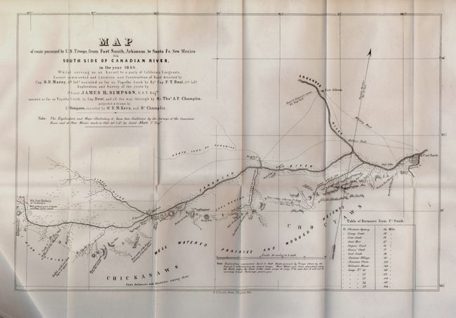
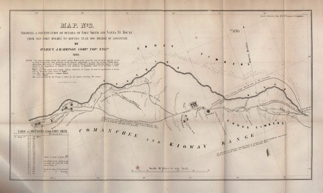
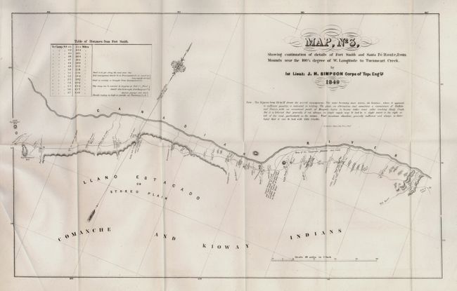
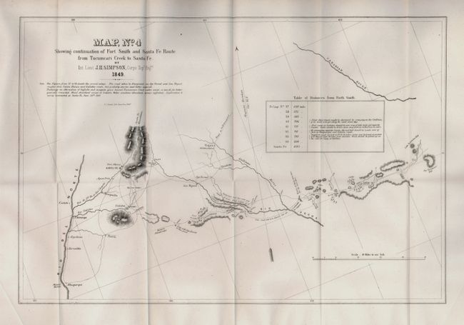
"Fort Smith and Santa Fe Route with Report", U.S. War Department

Subject: New Mexico

Period: 1850 (dated)

Publication: Senate Doc. 12, 31st Congress 1st Session

Color: Black & White

Size:
6 x 9.3 inches
15.2 x 23.6 cm
Download High Resolution Image
(or just click on image to launch the Zoom viewer)

This historical and finely detailed set of maps covers the route of the expedition on a scale of 10 miles to the inch. The four sheets display the entire route, which initially crossed present-day Oklahoma, continued along the Canadian River to the llano Estacado in Texas' panhandle and finally into eastern New Mexico. Filled with details encountered along the way, it includes forts, rivers and creeks, topography, and many notes on wildlife, geological, emigrant roads, Indian tribes and villages, availability of water and wood, and much more. Every camp site is located and numbered. A table of distances appears on each map. One curious note just east of Albuquerque states that "Fish with legs found in this pond." This expedition represents the first detailed mapping of the area, and Simpson found the route to be "superior" and practicable for a railroad. The survey was made with a chain and compass checked by astronomical observations made with a sextant and chronometer. Simpson credits the surveys of the Canadian River and of New Mexico, made in 1845 - 46 & 47, by Lieut. T. Abert of the Topographical Engineers in the preparation of his maps. The maps were drawn by Lt. Simpson with the assistance of Mr. E.M. Kern and Mr. Champlin. Wheat notes the original drawings for these four maps are preserved in the National Archives. See Wheat Volume III for further details on the importance and accomplishments of Simpson' expedition. The maps fold into the original report "Report from the Secretary of War… Report and Map of the Route from Fort Smith, Arkansas, to Santa Fe, New Mexico, Made by Lieutenant Simpson." Bound in blue leather with 25-page report.

Map No. 1 - Map of route pursued by U.S. Troops, from Fort Smith, Arkansas, to Santa Fe, New Mexico via South Side of Canadian River, in the year 1849 (19 x 12.3"). The map details the course of the Canadian and Arkansas Rivers from Old Fort Holmes or Chateau's in the west to Fort Smith. The map is well detailed along the rivers, noting North Fork Town, Fort Coffee, Fort Gibson, and the Choctaw Agency. Delineates various military roads and trails including the road to Edward's across the Deep Fork, Webber's Falls road, the upper wagon route from Ft. Smith, and more. Table at lower right gives the distances from Ft. Smith.

Map No. 2 - Showing a Continuation of Details of Fort Smith and Santa Fe Route from Old Fort Holmes to Mounds Near 100 1/2 Degree of Longitude (19.5 x 11"). This sheet continues to follow the Canadian River as it passes Antelope Hills on its way to Old Fort Holmes or Chateau's. Good detail of the Emigrants route and its crossing of the river.

Map No. 3 - Showing Continuation of Details from Fort Smith and Santa Fe Route from Mounds Near 100 1/2 degree of W. Longitude to Tucumcari Creek (20 x 12.3"). This sheet covers the region between Big Tucumcari Hill to about 100°30' longitude. With good detail of watershed and topography south of the river, the map locates many creeks, waterholes, and springs. Notation along a trail says that "Many of the Emigrants followed this route."

Map No. 4 - Showing Continuation of Details of Fort Smith and Santa Fe Route from Tucumcari Creek to Santa Fe (18.7 x 12.5"). The final map extends in the west from the Rio Del Norte to the Big Tucumcori Hill. Locates Santa Fe, Fort Marcy, Albuquerque, Vegas, and more. Along the many branches of the Rio Pecos are located cedar tree stands, topographical and other detail. The important emigrant routes are noted with variations carrying comments like "This road said to be shortest, but not practicable for wagons."

References: Wheat (TMW) #640.

Condition: A+

Fine condition except map No. 2 which has general light foxing.

Estimate: $300 - $400

Sold for: $400

Closed on 2/20/2008

Archived