Catalog Archive
Auction 123, Lot 222

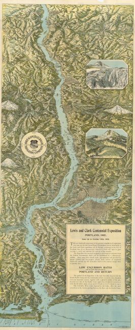
"The Columbia River through the Cascade Mountains to the Pacific Ocean", Railroad Companies, (Various)

Subject: Northwestern United States

Period: 1904 (dated)

Publication:

Color: Printed Color

Size:
18 x 43 inches
45.7 x 109.2 cm
Download High Resolution Image
(or just click on image to launch the Zoom viewer)

This is a fabulous birds-eye-view of the Columbia River published to celebrate the Lewis and Clark Centennial Exposition in Portland, Ore. The view of the lower Columbia River extends from Arlington to the Pacific Ocean. The map has superb topographical detail, and includes the names and elevations of the area's main mountains; St. Helens, Hood and Adams. The cities on the map have good grid detail, showing buildings, parks and train stations. A pair of colorful, nicely engraved vignettes of Mt. Hood (Eliot Glacier and Cloud Cap Inn) help make this a visually stunning example. Numerous beautiful black and white photographs illustrate the informational text on verso. Produced by the Oregon Railroad and Navigation Co. the map folds into purple covers with red and black text in an Art Nouveau design. A handsome and scarce issue.

References:

Condition: A

Several fold separations repaired with archival tape on verso, and a small amount of loss in blank upper margin, well away from image. Previous owner's name stamped inside front cover. Covers a little sunned.

Estimate: $300 - $400

Sold for: $325

Closed on 2/20/2008

Archived