Catalog Archive
Auction 123, Lot 153

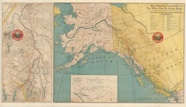
"Map of White Pass & Yukon Route [on sheet with] Map Showing Connections of the White Pass & Yukon Route", Railroad Companies, (Various)

Subject: Alaska and Western Canada

Period: 1905 (dated)

Publication:

Color: Printed Color

Size:
27.3 x 15 inches
69.3 x 38.1 cm
Download High Resolution Image
(or just click on image to launch the Zoom viewer)

An attractive and very detailed railroad timetable map produced during the Alaskan Gold Rush. The main map shows the entire region encompassing the Yukon and Alaska Territories, while a second map, at left, shows a close up of the area from Glacier Bay in the south, to Dawson in the Klondike region. The larger map includes a table of distances from Skaguay (Skagway) to various other locales, and an inset titled Map of the Tanana District showing T. M. R. R. and Creeks in Vicinity of Chena and Fairbanks. The maps provide a good amount of information regarding geology and mining, and there is even a note regarding the length of rapids, the speed of the current, and the height of waterfalls along a section of the 50 Mile River. On verso is a timetable for the railroad, and a good amount of tourist and mining information; this side of the brochure is nicely illustrated with attractive black and white photography. The map folds into pictorial printed wrappers. Published by the Franklin Company, Chicago, Ill., April 1905.

References:

Condition: A

A very nice example. Small stamped name of previous owner on cover.

Estimate: $140 - $180

Sold for: $150

Closed on 2/20/2008

Archived