Catalog Archive
Auction 121, Lot 81

"L'Amerique Septentrionale ou la Partie Septentrionale des Indes Occidentales ou se Trouve le Canada ou Nouvelle France la Floride la Virginie les Isles Antilles…", Coronelli/Nolin

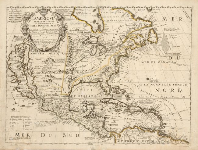
Subject: North America

Period: 1704 (dated)

Publication:

Color: Hand Color

Size:
23 x 17.3 inches
58.4 x 43.9 cm
Download High Resolution Image
(or just click on image to launch the Zoom viewer)

A spectacular map of North America features California as an island on the Foxe model with two indented bays at top. A note near the peninsula of Agubela de Cato speculates on the location of the Strait of Anian. The Mississippi River is located too far west, and it is flanked by a massive mountain range. The Great Lakes are shown quite accurately for the time, with Lake Ontario named Frontenac. The Chesapeake Bay is shown a bit too wide, and the fictitious Lake May is noted just south of the Appalachians. The decorative cartouche incorporates two horns of plenty that empty their contents of treasure into the waiting hands of a native and a European. Coronelli, royal cosmographer of the Republic of Venice, visited Paris in 1681-3, where he had access to court documents including the manuscripts of La Salle. Upon his return to Venice in 1684, he founded a geographical society, which provided funding for his atlas, first published in 1690. Third state of the map, published by Jean Baptiste Nolin.

References: McLaughlin #99.3.

Condition: B

A good impression on sheet with a number of small repaired holes and a few spots of foxing. The original outline color is faded.

Estimate: $4,000 - $5,000

Sold for: $4,000

Closed on 9/26/2007

Archived