Catalog Archive
Auction 121, Lot 288

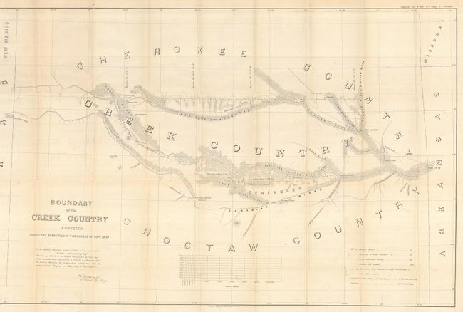
"Boundary of the Creek Country Surveyed Under the Direction of the Bureau of Topl Engs.", U.S. War Department

Subject: Oklahoma

Period: 1858 (published)

Publication: HR Doc. #104. 35th Congress 1st Session

Color: Black & White

Size:
37.2 x 24 inches
94.5 x 61 cm
Download High Resolution Image
(or just click on image to launch the Zoom viewer)

This report by Sitgreaves and Lt. J.C. Woodruff features a large map that covers the area between the Canadian River and the Red Fork of the Arkansas River in Indian Territory, and extends from Fort Smith to the border with New Mexico Territory. Locates the lands of the Cherokee, Creek, Seminole and Choctaw Indians, with numerous forts and connecting roads. Talasee is shown at the site of Tulsa. Other interesting place names such as Post Oak and Black Jack. 32 pages with one map. Rarely offered with the original report.

References: Phillips (M) p.251.

Condition: B+

Map has some very light offsetting and a couple very small intersectional fold separations. A very good, disbound example.

Estimate: $140 - $200

Sold for: $70

Closed on 9/26/2007

Archived