Catalog Archive
Auction 121, Lot 208

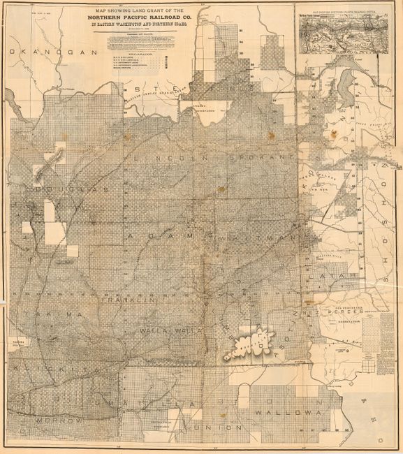
"Sectional Map Showing the Lands of the Northern Pacific Railroad Co. in Eastern Washington and Northern Idaho", Railroad Companies, (Various)

Subject: Northwestern United States - Railroads

Period: 1895 (circa)

Publication:

Color: Black & White

Size:
34 x 38.5 inches
86.4 x 97.8 cm
Download High Resolution Image
(or just click on image to launch the Zoom viewer)

This is a scarce land promotion broadside, published by the Northern Pacific Railroad. It features a very large and detailed map that was designed to promote the sale of lands along the railroad. Legend locates the available lands of several railroads and government agencies. The terms of sale limit settlers to 320 acres with prices ranging from $1.00 to $10.00 per acre. Inset map at upper right is "Map Showing the Northern Pacific Railway System" between St. Paul/Minneapolis and the Pacific Ocean. On verso are numerous photographs, advertisements and articles replete with information on climate, topography, government, natural resources, all designed to sell the region to the potential immigrant. Also with a Map of Oregon, Washington, and Part of Idaho, 9" x 12", that shows additional railroads and more. Folds in to self covers (5" x 9") titled "Sectional Land Map of Eastern Washington and Northern Idaho Traversed by the Northern Pacific Railroad…"

References:

Condition: C+

The map has several long fold separations and a few spots. Will benefit from professional attention to splits.

Estimate: $100 - $140

Sold for: $75

Closed on 9/26/2007

Archived