Catalog Archive
Auction 121, Lot 166

"Belgii Novi, Angliae Novae, et Partis Virginiae Novissima Delineatio", Jansson/Valck & Schenk

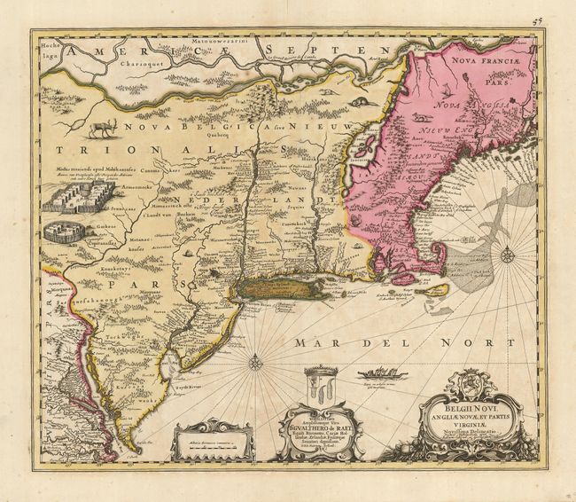
Subject: Colonial New England

Period: 1694 (circa)

Publication:

Color: Hand Color

Size:
22.3 x 17.3 inches
56.6 x 43.9 cm
Download High Resolution Image
(or just click on image to launch the Zoom viewer)

Please see lot 430 for additional map of New England.

This great map is one of the fundamental landmark maps of the seventeenth century. It was copied almost exactly on at least twenty-seven later maps, and it formed the beginning of the famous Jansson-Visscher series. Compiled from numerous manuscript and printed sources, the map follows the general outline of Adriaen Block's chart of 1614 with the St. Lawrence River and Lake Champlain based on Champlain. Virtually all European settlements are depicted with several English settlements appearing for the first time on Jansson's map. The map is lavishly embellished with engravings of local game and two large Indian villages, all derived from Blaeu. This is the third state with the added dedication to Gualthero de Raet with his coat of arms and the imprint of Valk and Schenk.

References: Burden #305; Fite & Freeman pp. 146-8; Tooley (Amer) p. 284, plt. #146.

Condition: B+

A nice impression with original color and wide margins. The green color has oxidized and has been reinforced on the verso to repair minor cracking.

Estimate: $5,000 - $6,000

Sold for: $3,750

Closed on 9/26/2007

Archived