Catalog Archive
Auction 119, Lot 292

"An Accurate Map of The Country round Boston in New England from the best Authorities [on sheet with] A Plan of Boston and Charlestown; from a Drawing made on 1771", Anon.

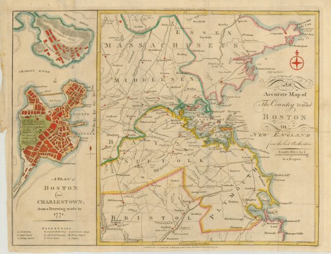
Subject: Massachusetts, Boston

Period: 1776 (dated)

Publication: Town & Country Magazine,

Color: Hand Color

Size:
16.3 x 12.3 inches
41.4 x 31.2 cm
Download High Resolution Image
(or just click on image to launch the Zoom viewer)

Very uncommon Revolutionary War map made for the January 16th, 1776 edition of Town & Country Magazine, showing two maps on one sheet. The map on the left was based on a 1771 drawing of the city just after the Boston Massacre of 1770, and it shows Boston and Charlestown with the major streets and buildings named, including Faneuil Hall. An encampment of Redcoats are shown right next to a small depiction of the Liberty Tree. The Liberty Tree was an elm tree located at about Washington and Essex streets and used as a meeting place by the Sons of Liberty, who formed after the Stamp Act if 1765. The tree was attacked by British Loyalists in 1775 and burned, but remained a popular symbol, encouraging other colonialists to erect Liberty poles, hung with flags depicting the Liberty Tree. After the massacre, all British soldiers were moved out to a fort on Castle Island to avoid additional unrest. The second map shows the surrounding countryside from Ipswich, Gloucester and Cape Ann down to Plymouth, and as far west as Providence and Groton. A fascinating map from the birth of the United States.

References: Jolly TOWN-2; Sellers & Van Ee #894; Nebenzahl (Biblio) #14 & 14a.

Condition: B

Nice impression. The map has folds as issued, and it has a few spots of separation at fold intersections. The left binding side has a tear that is repaired on the verso with an old paper patch.

Estimate: $1,100 - $1,500

Sold for: $800

Closed on 5/9/2007

Archived