Catalog Archive
Auction 119, Lot 220

"Economic Map of Portions of Wyoming, Idaho and Utah", Hayden, Ferdinand Vandeveer

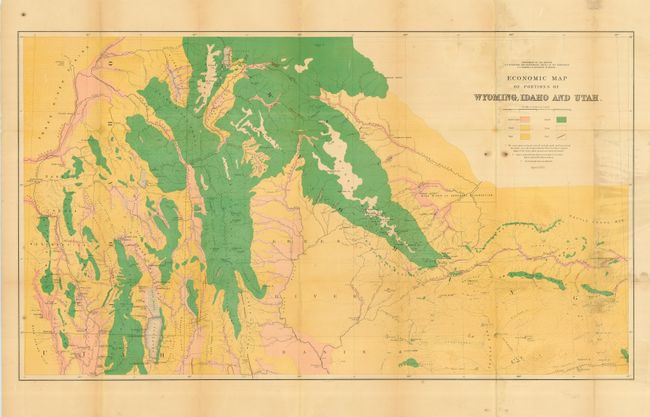
Subject: United States - Western

Period: 1879 (dated)

Publication: H.R. Doc. 2, 37th Congress, 1st Session

Color: Printed Color

Size:
See Description
Download High Resolution Image
(or just click on image to launch the Zoom viewer)

This map was one of six included in Hayden's 12th Annual Report published in 1883. It is a beautifully executed chromolithographed map that details the land types of the region. The map covers the area from Jackson Lake and the Tetons in the north and south to below Bear Lake, Logan and Robinson's Ferry on the Green River. It extends from Blackfoot, Idaho in the west to Rawlings, Wyoming in the east. A color/style legend identifies land types including arable land, grass, sage, forest, and rock. Coal deposits are identified via red over printed lines. It is a very detailed chart drawn on a scale of 1 inch per 8 miles with geology by A.C. Peale, Orestes St. John, and F.M. Endlich.

References: Wheat (TMW) #1296.

Condition: B

Issued folding, now pressed and backed with archival tissue. Strong color and full, original margins. Some water stains and mildew along right side of map, the balance of the map is near fine.

Estimate: $100 - $140

Sold for: $75

Closed on 5/9/2007

Archived