Catalog Archive
Auction 118, Lot 892

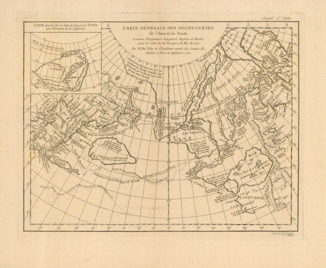
"Carte Generale des Decouvertes de l'Amiral de Fonte, et autres Navigateurs Espagnols, Anglios et Russes pour la recherche du Passage a la Mer du Sud Par M. De I'Lsle de l'Acadmie royale des Sciences &c. Publiee a Paris en Septembre 1752", Robert de Vaugondy, Didier

Subject: Western North America

Period: 1752 (dated)

Publication: Encyclopedie: Suite du Recueil des Planches, sur les Sciences…

Color: Black & White

Size:
15 x 11.5 inches
38.1 x 29.2 cm
Download High Resolution Image
(or just click on image to launch the Zoom viewer)

When Charles Joseph Panckoucke took over publication of Diderot's Encyclopedie in 1768, he promised to correct the cursory treatment of geography for which the first seventeen volumes had been criticized, with emphasis on the discoveries of the last 25 years. He employed Samuel Engel, a Swiss geographer, to write a series of articles about the northern regions and Didier Robert de Vaugondy to prepare ten maps to illustrate them. Engel rejected the De la Fonte Northwest Passage discoveries and believed the most sensible route from the Atlantic to the Pacific was along the north coast of Siberia. These maps illustrate the discoveries and various cartographic theories concerning the Pacific Northwest, East Asia and the North Pacific Ocean and include some of the most interesting comparative cartography of the eighteenth century

This is one of the more remarkable combinations of fact and fiction ever published. This map of the North Pacific and Northwest had as its source a 1708 article in the Monthly Miscellany that purported to be a newly discovered account of a voyage in 1640 by the Spanish Admiral, Bartholomew de Fonte. Thereafter, the newly presented information was changed and elaborated upon, notably by this series of maps which appeared in Diderot's Encyclopedia. In its concept, it promoted the hopes of a Northwest Passage and depicts the existence of Mer de l'Ouest or the Sea of the West. The tracks for the Russian exploration in 1741 are traced, as well as the purported track of Admiral de Fonte. Inset at upper left "Carte dressee Sur la lettre de l'Amiral de Fonte par l'Ecrivain de la Californie."

The title credits Delisle as the source for the map. There was much controversy at the time regarding the veracity of the voyages by de Fonte. In 1750, Joseph-Nicolas Delisle presented a paper and map at the Academy of Sciences in Paris that consolidated the vast amount of geographical information he had acquired in Russia. The paper caused a sensation, but the map, drawn by Philippe Buache and designed to show the "coherence of Russian discoveries with those of de la Fuente" (de Fonte), was met with skepticism. Delisle hired Bellin to re-work the map, presenting it to the Academy in 1752. That same year an annoyed Buache drew his own map and presented it along with a paper to the Academy. The controversy was further enflamed by Robert de Vaugondy's own presentation to the Academy the following year when he expressed his doubts about the truth of de Fonte’s voyages and criticized the maps illustrating it. See Pedley pages 74-78 for more on the politics and personalities in this fascinating story.

References: Hayes pp. 26-27; Pedley #454.

Condition: A

Good impression on a large sheet with very wide margins. Slight hit of centerfold toning mostly in upper portion, still very good.

Estimate: $250 - $350

Sold for: $180

Closed on 3/6/2007

Archived