Catalog Archive
Auction 118, Lot 399

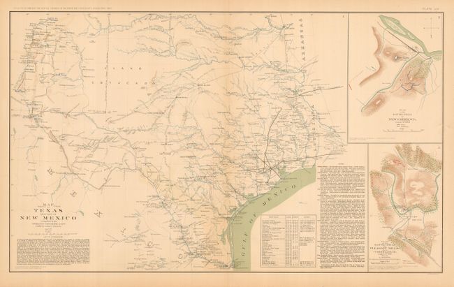
"Map of Texas and Part of New Mexico Compiled in the Bureau of Topographic Engrs. Chiefly for Military Purposes 1857", U.S. Government

Subject: Texas

Period: 1891 (published)

Publication: Atlas to Accompany the Official Records of the Union and Confederate Armies…

Color: Printed Color

Size:
27.5 x 16.5 inches
69.9 x 41.9 cm
Download High Resolution Image
(or just click on image to launch the Zoom viewer)

This finely lithographed map of the state has much detail throughout. Locates settlements, forts, trails and fords with topography and watershed shown. The map contains extensive notes on rivers, list of authorities, and a table of stations with locations and authorities. Martin & Martin say "With the onset of the Civil War, the federal exploration and mapping efforts in the West ceased, and many federal troops there either withdrew or surrendered … Shortly after assuming command of the Gulf in 1862 and while planning his offensives in New Orleans, Banks dispatched a report to Washington containing a map of the Texas region. The map had been prepared from various sources shortly before the war, and it was an excellent example of a military planning document…" It was originally drawn in 1857 and was utilized by Banks in 1862, but was not published until its appearance in the Official Records atlas of the 1890's. This historical map documents the status of the frontier immediately prior to the outbreak of the Civil War. With two unrelated inset maps at right: "Plan of Battle Field at New Creek West Virginia August 4th 1864" and "Plan of Battle at Pleasant Mills near Cumberland Md. August 1st 1864." Lithographed by Julius Bien & Co., Baltimore.

References: Martin & Martin #45

Condition: A

Near fine example with just a hint of centerfold toning.

Estimate: $180 - $250

Sold for: $140

Closed on 3/6/2007

Archived