Catalog Archive
Auction 118, Lot 389

"Geological Map of Tennessee by J.M. Safford, A.M., Ph.D.", Taintor Brothers
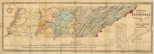
Subject: Tennessee

Period: 1869 (dated)

Publication: Safford's Geology of Tennessee

Color: Hand Color

Size:
44 x 15 inches
111.8 x 38.1 cm
Download High Resolution Image
(or just click on image to launch the Zoom viewer)

Handsome and colorful map that illustrates the geological deposits and formations throughout Tennessee. This is a very early geological map of Tennessee and was published to accompany Safford's report. Safford was the State Geologist of Tennessee following the Civil War. The map shows 13 formations, subdivided to locate a total of 33 sub-classes, 18 shown with hand coloring. Large inset at right beneath the title is "Map of the Principal Faults in East Tennessee." Smaller inset is "The Well's Creek Basin in Stewart Country." Below the map is a large and well drawn profile of the state showing stratums and formations on a vertical scale of 2000 feet per inch. Drawn by Safford and lithographed by Ferd. Mayer & Sons, General Lith's, of New York. A most uncommon and seldom seen geological map.

References:

Condition: B

Issued folding, this example has early linen backing that is not sectionalized. Some light stains or foxing, fold intersection splits, and long tear from bottom.

Estimate: $500 - $600

Sold for: $350

Closed on 3/6/2007

Archived