Catalog Archive
Auction 118, Lot 227

"Carte Generale des Etats-Unis de l'Amerique Septentrionale Divisee en ses 17 Provinces", Rochefoucald Liancourt, Francois Alexander

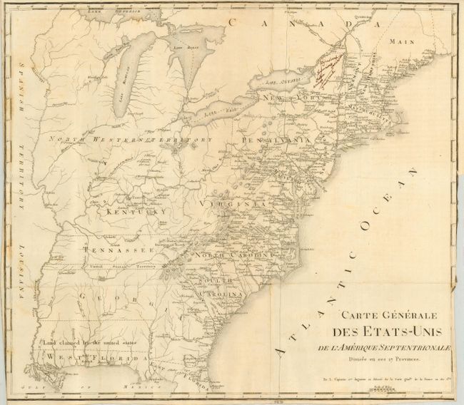
Subject: United States - Eastern

Period: 1800 (dated)

Publication: Voyage dans les Etats-Unis… (Travels through the United States)

Color: Black & White

Size:
18.5 x 15.5 inches
47 x 39.4 cm
Download High Resolution Image
(or just click on image to launch the Zoom viewer)

This is a French edition of the general map of Rochefoucald Liancourt's travels in the United States. The entire map is in English, only the title is in French, which continues "Par L. Capitaine Ier. Ingenieur et Asocie' de la Carte genele. de la France en 180 fles." The map extends south to include part of East and West Florida. The western boundary of Georgia extends to the Mississippi River. A thin strip of land extending westward between Georgia and Tennessee is called United States Territory. This region originally belonged to South Carolina but was ceded back to the United States in 1787. Further south a wide strip of land between Georgia and West Florida is Land claimed by the United States referring to the disputed region between the United States and Spain. The map is filled with a remarkable number of place names and details including a well developed road system in the nascent nation. The large, mostly blank Maine is here labeledMain.

References: cf Phillips (M) p. 873.2

Condition: B

A few spots, otherwise a very good example with sharp impression printed on fine hand laid paper with large watermark. Issued folded with close margins and binding trim.

Estimate: $400 - $500

Sold for: $300

Closed on 3/6/2007

Archived