Catalog Archive
Auction 118, Lot 204

"Carte des Possessions Angloises & Francoises du Continent de l'Amerique Septentrionale [also] Kaart van de Engelsche en Fransche Bezittingen in het Vaste Land van Noord America", Ottens, Reiner and Joshua

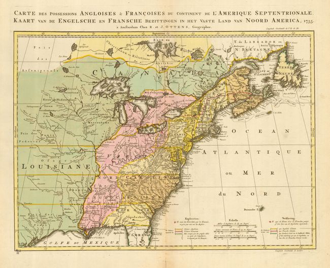
Subject: Colonial United States and Canada

Period: 1755 (dated)

Publication:

Color: Hand Color

Size:
22 x 16 inches
55.9 x 40.6 cm
Download High Resolution Image
(or just click on image to launch the Zoom viewer)

This is the Dutch version of Jean Palairet and Thomas Kitchen's important map showing the French and English territorial claims on the eve of the French and Indian War. The Palairet/Kitchen map was in turn based on John Mitchell's index of his large, epic map of the region. The Great Lakes are beautifully illustrated with Lake Superior still sporting the imaginary island of Philippeaux. The map is filled with meticulously engraved detail of towns, forts, roads, and tribal lands. Title and notations are in both French and Dutch. Beautiful original color delineates the French and British colonies and those lands in dispute between the two powers. The French forts are noted with a tiny, red circle around them.

References: McCorkle #755.9; Seller and Van Ee #58.

Condition: B

Exceptionally sharp impression with light toning on centerfold. Tiny initial stamp from a prior owner in lower left corner of map, just on neatline. Old paper repair on lower centerfold verso.

Estimate: $1,900 - $2,300

Sold for: $1,400

Closed on 3/6/2007

Archived