Catalog Archive
Auction 118, Lot 191

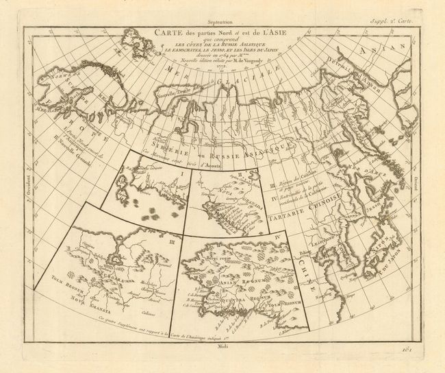
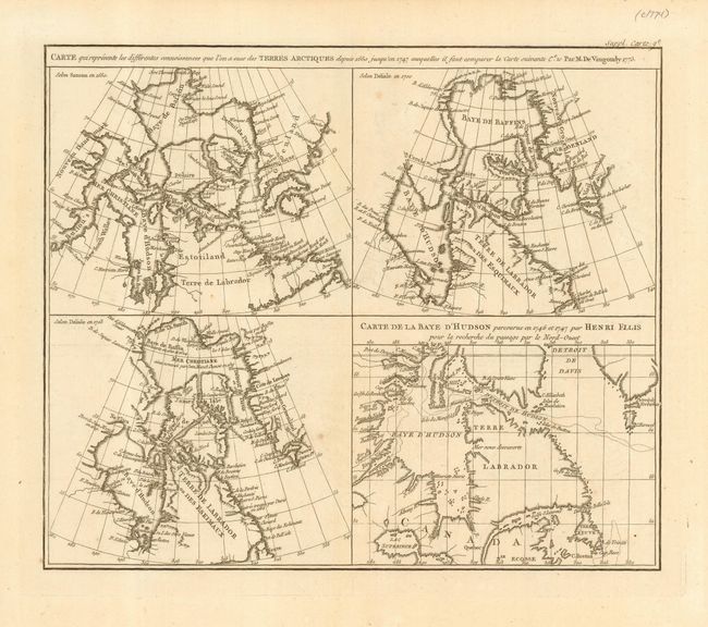
"[Lot of 2] Carte des parties Nord et est de l'Asia qui comprend les Cotes de la Russie Asiatique le Kamschatka, le Jesso, et les Isles du Japon [together with] Carte qui represente les differentes connoissances...Terres Arctiques…", Robert de Vaugondy, Didier

Subject: Canadian Arctic, Pacific Northwest and Northern Asia

Period: 1772/3 (dated)

Publication: Diderot's Encyclopedie, Supplement

Color: Black & White

Size:
13.5 x 11.5 inches
34.3 x 29.2 cm
Download High Resolution Image
(or just click on image to launch the Zoom viewer)

When Charles Joseph Panckoucke took over publication of Diderot's Encyclopedie in 1768, he promised to correct the cursory treatment of geography for which the first seventeen volumes had been criticized, with emphasis on the discoveries of the last 25 years. He employed Samuel Engel, a Swiss geographer, to write a series of articles about the northern regions and Didier Robert de Vaugondy to prepare ten maps to illustrate them. Engel rejected the De la Fonte Northwest Passage discoveries and believed the most sensible route from the Atlantic to the Pacific was along the north coast of Siberia. These maps illustrate the discoveries and various cartographic theories concerning the Pacific Northwest, East Asia and the North Pacific Ocean and include some of the most interesting comparative cartography of the eighteenth century

Very intriguing set of maps that offer a fascinating and informative over view of some of the early cartographic theories concerning the western part of North America as well as the Arctic search for a Northwest Passage. 1) Carte des parties Nord et est de l'Asia... This unusual map details the northern coastline from Scandinavia through to the eastern coast of Asia to just below Nanking, and a bit of the coast of America called Anian. Japan is shown with the imaginary island of Jesso above it. Inset into the map are four small maps of the western part of North America: I - Features the entire western coast with Japan just a short distance offshore. II - Focuses on Nova Granada showing the Mexican coast of the Gulf of California. III - Focuses on the Zubgara and Tolm Regnum of Nova Granada and the mythical seven cities of Cibola. IV - Covers Anian Regnum, which includes Quivira Regnum and another Tolm Regnum. 2) Carte qui represente les differentes connoissances que l'on a eues des Terres Arctiques depuis 1650. Four maps on one sheet illustrating the cartography of Sanson in 1650, Delisle in 1700 and 1703 and Henri Ellis in 1746-47. All depicting the Hudson and Baffin Bay region showing the development of the region's cartography between 1650 and 1747.

References: Pedley #24 & 406.

Condition: A

Both maps near fine with just a few, almost invisible spots. Hinge remnants at top margin.

Estimate: $300 - $400

Sold for: $220

Closed on 3/6/2007

Archived