Catalog Archive
Auction 118, Lot 161

"A Chart of the North Part of America Describing the Sea Coast of Groenland Davies Streights Baffins Bay Hudsons Streights Buttons Bay and James Bay", Seller, John

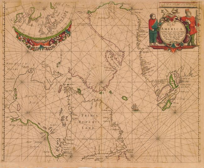
Subject: Canada and Greenland

Period: 1675 (circa)

Publication: Atlas Maritimus or A Book of Charts…

Color: Hand Color

Size:
21.3 x 17 inches
54.1 x 43.2 cm
Download High Resolution Image
(or just click on image to launch the Zoom viewer)

This striking sea chart of Hudson and Baffin bays is from John Seller's extremely rare sea atlas. The cartography shows the extent of exploration in this region, with Greenland exhibiting the three-island configuration popularized by Sanson. Labrador and the Ungava Peninsula is named Prince Rupert's Land, in reference to the Hudson Bay Company holdings. There are some interesting notations on the west coast of Hudson Bay (here Buttons Bay), noting Hubberts Hope, Hope Checkt and Hope Advanced. The map has a decorative cartouche featuring a mitten-clad and gun-toting trapper, some foxes, and a native. The upper left of the map has an inset polar projection of the area mapped expanded farther eastward to take in Scandinavia and Arctic Russia.

John Seller was a pioneering British publisher of nautical charts and one of the most important figures in the early history of British cartography. Seller's shop, located near the Tower of London in Wapping, became a gathering place for seamen arriving with the latest news of distant places and provided Seller with information critical to his nautical chart business. In addition to sea charts he produced a vast array of cartographic material, the first to rival the large Dutch firms such as Blaeu and Jansson. Seller was appointed Royal Hydrographer by Charles II in 1671, and also served under James II and William III. Unfortunately his business was built on a shaky foundation and though he made several attempts to avoid bankruptcy, including a consortium partnership with other cartographers such as William Fisher and John Thornton, he was ultimately unsuccessful.

References: Kershaw #213.

Condition: B

Great impression with original color. Overall toning and a few spots of foxing. Some damp stain in the upper corners. Hinge remnants on verso. Printed on very sturdy, double thick paper that was commonly used for sea charts.

Estimate: $1,500 - $2,000

Sold for: $2,100

Closed on 3/6/2007

Archived