Catalog Archive
Auction 117, Lot 43

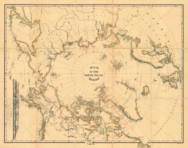
"Map of the North Polar Region", U.S. Hydrographic Office

Subject: North Pole

Period: 1879 (published)

Publication: Narrative of the Second Arctic Expedition

Color: Printed Color

Size:
31 x 24 inches
78.7 x 61 cm
Download High Resolution Image
(or just click on image to launch the Zoom viewer)

A beautiful example of this infrequently seen circumpolar map that documents all Arctic explorations to date. This version is segmented to 15 sections and mounted on original linen. Red overprinting shows routes, locations, and important events of the major Arctic expeditions, from Hudson (1607 to 1610) to about 1880. The latest expedition shown is George S. Nares' 1876 attempt to reach the pole via Smith Sound and Robeson Channel and to explore the northern parts of Ellesmere Island as well as Northwest Greenland. Other expeditions noted include those of Perry, Mackenzie, Wood, Hayes, Beechey, Green, Rodgers, and Long. Large inset shows a sea view of "Wrangell Land As seen from the Bark Nile of New London, Capt. Th. Long. Aug. 14th 15th & 16th - 1867; 15 to 18 miles distance". Published by The Graphic Co., 39 & 41 Park Place, N.Y. Map folds into self wrappers of marbled paper, 6.6" x 8.8". A very lovely example of this chart in the rare segmented version. Engraved by Wm. Bauman.

References:

Condition: A

Near fine example less one small burn mark in blank ocean at lower right.

Estimate: $350 - $450

Sold for: $250

Closed on 12/6/2006

Archived