Catalog Archive
Auction 117, Lot 363

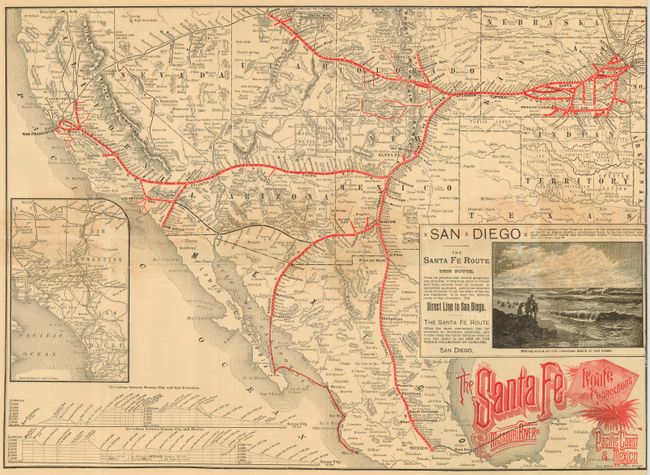
"The Santa Fe Route and Connections Missouri River to Pacific Coast & Mexico", Railroad Companies, (Various)

Subject: United States & Mexico

Period: 1886 (dated)

Publication:

Color: Printed Color

Size:
21.3 x 15.3 inches
54.1 x 38.9 cm
Download High Resolution Image
(or just click on image to launch the Zoom viewer)

Folding map and timetable for the Santa Fe Route, which used the Atcheson, Topeka and Santa Fe Railroad, Atlantic and Pacific Railroad and the Mexican Central Railroad. This route traveled from Kansas, past Indian Territory, up though Colorado, with a line that went through New Mexico to Mexico, stopping at Guaymas and Vera Cruz. The Atlantic Pacific continued along from Albuquerque across to California. There are elevation charts for the points between Kansas City and San Francisco and Mexico. Great piece of railroad ephemera with an inset woodcut view of a Winter Scene on the Coronado Beach at San Diego featuring people at the beach with text extolling the mildness of San Diego's weather. The map is also inset with a map of southern California on the left. The timetable was printed by Rand McNally & Co.

References:

Condition: B

Generally good with some toning at the center along folds and a couple of fold intersection splits.

Estimate: $120 - $150

Sold for: $550

Closed on 12/6/2006

Archived