Catalog Archive
Auction 117, Lot 290

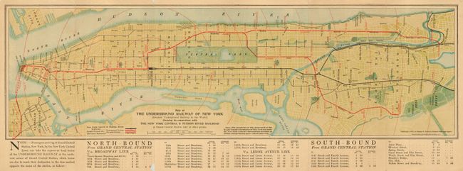
"Map of the Underground Railway of New York (Greatest Underground Railway in the World) Showing its connections…", Matthews-Northrup Co

Subject: New York

Period: 1905 (dated)

Publication:

Color: Printed Color

Size:
23.25 x 7 inches
59.1 x 17.8 cm
Download High Resolution Image
(or just click on image to launch the Zoom viewer)

This is a very early map of the New York Subway system, which was completed in 1904. Issued by the Passenger Department of the New York Central & Hudson River Railroad. The map extends north to above 200th Street to include the Bronx Park. Legend uses color to delineate the subway system, including above and underground rails, plus the New York Central & Hudson River railroad, and the Elevated Railways. The new subway is shown starting in Brooklyn at the Atlantic Ave. Station, running to the East River and a proposed section across the East River to the Battery. In Manhattan the line runs from the Battery to Grand Central Station, then up Broadway where the line splits. These two lines continue as far north as Bailey Ave in the west and the Bronx Park Station. Below the map is a full timetable for all stops. On the verso is a fine map of New York City. Size given is for the larger subway map. Above title is "Four-Track Series" No. 39.

References:

Condition: C

Folding pocket map with some fold separations and a little bit of loss on edges, as to be expected from an ephemeral map.

Estimate: $120 - $180

Sold for: $190

Closed on 12/6/2006

Archived