Catalog Archive
Auction 117, Lot 233

"Potomac Aqueduct. Hydrographic survey of the Potomac River near Georgetown…", U.S. Government

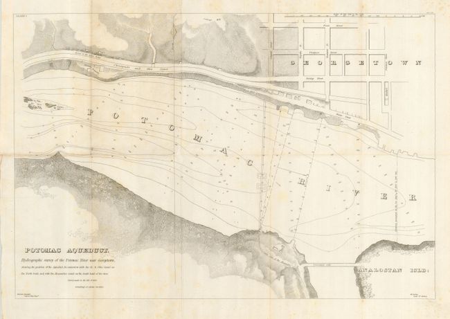
Subject: District of Columbia

Period: 1836 (published)

Publication: H. Doc. 261, 24th Cong., 1st Session

Color: Black & White

Size:
19 x 13 inches
48.3 x 33 cm
Download High Resolution Image
(or just click on image to launch the Zoom viewer)

Title continues, "shewing the position of the Aqueduct, its connection with the Ch. & Ohio Canal on the North bank, and the Alexandria Canal on the South bank of the river. Survey made in the fall of 1832." Lower left: William Turnbull Capt. U.S. Top. Engrs. Lower right: M.C. Ewing Lieut. 4th Artillery. This map was published in Turnbull's report of Jan. 1, 1836 and again in 1838 in H. Doc. 459, 25th Cong., 2nd Session. The proposed aqueduct crosses the Potomac River between Georgetown and present-day Rosslyn, Va. near where the Key Bridge is now located. This is a very large-scale map, covering 250 feet per inch and showing minute detail along the shore. The map shows the street grid of Georgetown to above First Street. Names Water, Bridge, Prospect, Lingan, Fayette, Frederick and Potomac Streets, and locates the market. Shows the causeway gate between the shore and Analostan Island and the Three Sisters Islands in the Potomac River. Also locates the Chesapeake and Ohio Canal running parallel to the road to Little Falls.

References: Claussen & Friis #141.

Condition: B

Folding as issued with full margins. No flaws except for some scattered light foxing mostly at upper left.

Estimate: $120 - $160

Sold for: $70

Closed on 12/6/2006

Archived