Catalog Archive
Auction 117, Lot 157

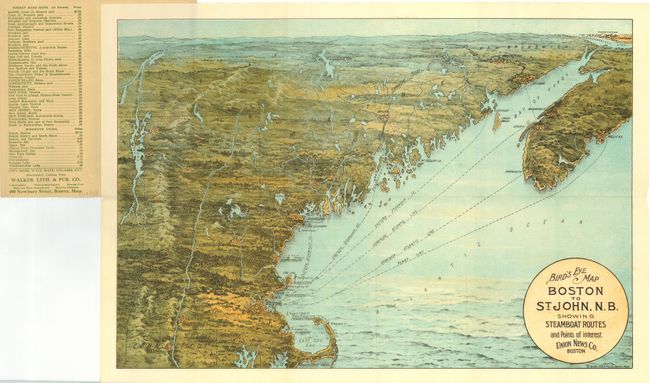
"Bird's Eye Map Boston to St. John, N.B. Showing Steamboat Routes and Points of Interest. Union News Co. Boston",

Subject: Boston, New England

Period: 1910 (circa)

Publication:

Color: Printed Color

Size:
19 x 13.3 inches
48.3 x 33.8 cm
Download High Resolution Image
(or just click on image to launch the Zoom viewer)

A terrific bird's-eye map of the region that was produced for the tourist trade by the Union News Company of Boston. The pocket map folds into paper covers with title the "Bird's-Eye View Map of Boston to St. John, N.B. Price 10 cents." The map extends from Nantucket Sound north to locate Portsmouth, Portland and Cape Elizabeth, Deer Island, East Port, St. John, and Charlottetown on the distant horizon. Also shows Bangor, St. Albans, Burlington, Rutland, Concord, Springfield, Hartford, and Providence. The title is contained in a circular cartouche. Ferry and ship routes are shown from Boston to points north. On the inside cover is an extensive list of maps available from Walker Lith. & Pub. Co. of Boston. The map is a fine chromolithograph.

References:

Condition: A

The folding map is fine with no flaws and lovely coloring. Paper covers with a little soiling or toning and glue remnant on back cover, likely from being pasted to a scrap book.

Estimate: $100 - $140

Sold for: $130

Closed on 12/6/2006

Archived