Catalog Archive
Auction 116, Lot 191

"Map of the Country Embraced in the Recent Campaign against the Hostile Sioux Indians of Dakota Showing the Different Positions of Troops from the Beginning to the Surrender in January, 1891", U.S. Army

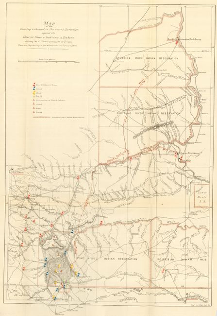
Subject: Midwestern United States

Period: 1891 (dated)

Publication:

Color: Printed Color

Size:
14.8 x 21.3 inches
37.6 x 54.1 cm
Download High Resolution Image
(or just click on image to launch the Zoom viewer)

This is a terrific map of considerable historical significance as it shows the location of the Battle of Wounded Knee, here labeled as 'Affair at Wounded Knee, Dec 29, 1890'. A misunderstanding between soldiers and Indians waiting to surrender at Wounded Knee, South Dakota, touched off a massacre of some 300 Sioux men, women and children. The campaign was an attempt to suppress the Ghost Dance movement. At the height of the tension, Sitting Bull was killed. The location of his camp is noted on the map. In exceptional detail, scores of wagon roads and trails are laid out, many named, numerous military positions with red, yellow and blue overprinted icons are keyed to legend. The icons locate the first, second, third and fourth position of the troops, along with the same number of positions of Hostile Indians. The map locates numerous forts and all Indian reservations in the region including Lower Brule, Pine Ridge, Rosebud and Standing Rock. A surprising number of settlements including Valentine, Clinton, Hay Springs, Wayside, Moulton, Rapid City, Cheyenne City, the Standing Rock Agency and much more are named. Prepared by the Eng'r Off. Hdqrs Dept. of Missouri.

References:

Condition: A+

Folding, as issued with full margins.

Estimate: $200 - $250

Sold for: $275

Closed on 9/20/2006

Archived