Catalog Archive
Auction 116, Lot 149

"Recens Edita totius Novi Belgii, in America Septentrionali siti, delineatio cura et Sumtibus", Seutter, Matthias

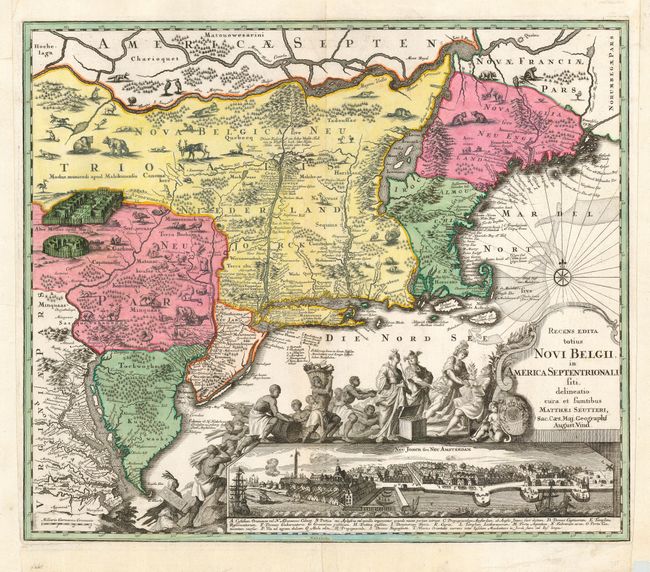
Subject: Colonial New England and Mid-Atlantic

Period: 1730 (circa)

Publication:

Color: Hand Color

Size:
23 x 19.6 inches
58.4 x 49.8 cm
Download High Resolution Image
(or just click on image to launch the Zoom viewer)

This lovely copper engraved map is Seutter’s version of the famous Jansson-Visscher series of maps of New England. According to Campbell, this is the first map in the series to show by printed lines the boundaries of Massachusetts, New England, New York, New Jersey and Pennsylvania. These boundaries were previously left to the discretion of colorists, resulting in much variation. A well engraved and rendered bird's-eye view of New York City (Neu Jorck sive Neu Amsterdam) supports a grand pictorial cartouche that depicts England’s George II being presented with the bounty of the colonies. Many Dutch place names and notes have been converted to Latin or German. This example is the second state with "Sac. Caes. Maj. Geographi August. Vind." beneath the title.

References: McCorkle #730.5; Tooley (Amer), Campbell, p. 291, #24, plt. 161.

Condition: B

Beautiful, bright, early impression with good coloring. Trimmed to neatline at sides with period paper laid in. Also trimmed at bottom that enters border toward center with paper laid and facsimile of border. Otherwise in fine condition.

Estimate: $3,500 - $4,500

Sold for: $2,500

Closed on 9/20/2006

Archived