Catalog Archive
Auction 116, Lot 147

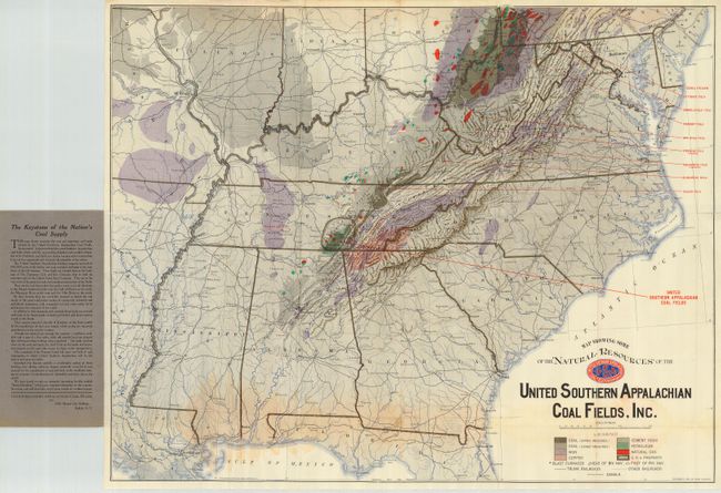
"Map Showing Some of the Natural Resources of the United Southern Appalachian Coal Fields, Inc.", Matthews-Northrup Co

Subject: Eastern United States

Period: 1910 (dated)

Publication:

Color: Printed Color

Size:
26.8 x 21.8 inches
68.1 x 55.4 cm
Download High Resolution Image
(or just click on image to launch the Zoom viewer)

Attractive thematic map that shows the distribution of minerals in the eastern half of the United States to just beyond the Mississippi River. The map extends from southern Pennsylvania to the panhandle of Florida. It is color coded to represent the coal, copper, iron, cement, petroleum, and natural gas deposits. It also locates blast furnaces, navigatable rivers, canals and railroads. Folding into tall 8vo paper wrappers, with the coal company's insignia on the cover in color. A very handsomely colored map and a fine example of Matthews-Northrup best work.

References:

Condition: A

Map is near fine with only a little water staining at bottom that is not distracting on this strongly printed and colored map. Cover is very good with just a little staining or sunning along bottom.

Estimate: $80 - $120

Sold for: $40

Closed on 9/20/2006

Archived