Catalog Archive
Auction 116, Lot 142

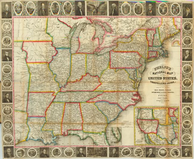
"Phelps's National Map of the United States, A Traveller's Guide", Ensign, Thayer & Co.

Subject: Eastern United States

Period: 1849 (dated)

Publication:

Color: Hand Color

Size:
25 x 20 inches
63.5 x 50.8 cm
Download High Resolution Image
(or just click on image to launch the Zoom viewer)

A nice example of the third edition of this folding pocket map. The map extends to the Great Plains and includes parts of Texas and Minnesota and a large unnamed region between them. The map is filled with details including roads, towns and villages, railroads, rivers and more. It is embellished with a surrounding border featuring finely engraved portraits of 16 famous Americans, the seals of 30 states including Texas but not California, the signing of the Declaration of Independence, and the seal of the United States. At lower right is a large inset "Map of Oregon, California & Texas" that actually shows all of western U.S. In it, the large territory of Oregon extends to the Continental Divide and a huge California and Texas occupy the entire Southwest with New Mexico named but shown within Texas. Map folds into original brown cloth blind-stamped covers (3.5 x 5.5") with gilt title and pictorial representations of an early train and the steamship St. Louis. It is still attached to back cover as issued.

References:

Condition: B

The map is very good with fine color and a bright impression, less a little loss within the inset map with toning above on fold. The loss is about 1/4" by a little over 1" long with paper repaired on verso. Covers are separated along spine.

Estimate: $600 - $800

Sold for: $500

Closed on 9/20/2006

Archived