Catalog Archive
Auction 115, Lot 249

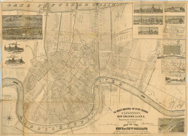
"The World's Industrial and Cotton Centennial Exposition… Plan No. 2 Map of the City of New Orleans Showing Location of Exposition Grounds…",

Subject: Louisiana, New Orleans

Period: 1890 (dated)

Publication:

Color: Black & White

Size:
36 x 26 inches
91.4 x 66 cm
Download High Resolution Image
(or just click on image to launch the Zoom viewer)

Large, lithographed pocket map that is linen backed and folds into gilt-stamped cloth covers. The very detailed map shows the entire city from Lake Ponchartrain to the Mississippi, naming individual streets, buildings, parks, fairgrounds, railroads, docks, and a few property owners along the Mississippi. With numerous insets and views including: Perspective View of the Buildings and Grounds, Mexican National Headquarters, Grand Rapids (Mich.) Furniture Pavilion, United States and State Exhibits, The Main Building, Agricultural Hall, Art Gallery, Factories and Mills, The Grounds Plans, Plan of New Orleans in 1770, View of New Orleans in 1719, and an untitled bird's-eye view of the South Pass. Lithograph by Southern Litho Co. 38 Natchez St., N.O.

References: Rumsey 5324

Condition: B

Covers a little rubbed and scuffed. Map has several rough areas at fold intersections, some with slight loss. Map has been poorly folded and has some soft creases, some rough edges. Neat pencil notes location of docks, steamships, barges along river.

Estimate: $150 - $250

Sold for: $900

Closed on 6/21/2006

Archived