Catalog Archive
Auction 115, Lot 174

"Virginia Marylandia et Carolina in America Septentrionali Britannorum industria excultae", Homann, Johann Baptist

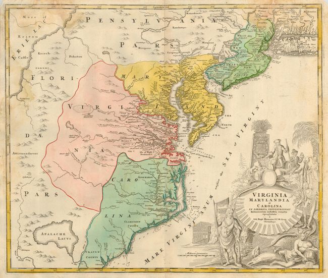
Subject: Colonial Mid-Atlantic

Period: 1765 (circa)

Publication:

Color: Hand Color

Size:
22.5 x 19.3 inches
57.2 x 49 cm
Download High Resolution Image
(or just click on image to launch the Zoom viewer)

Handsome map of the mid-Atlantic colonies balanced with a pictorial cartouche filling the lower right. There is a large hypothetical lake (Apalache Lacus) west of Craven County, Carolina. Some counties and many rivers of eastern Virginia are shown, but western Virginia is vague with only Germantown, Mister Krug's Plantation and Fort Christ Anna located. Florida is shown extending west of Virginia, all the way north to Lake Erie. Maryland along Cheseapeake Bay [sic] shows many rivers and towns with soundings in most bays. Philadelphia is clearly shown although Pennsylvania is divided by a rambling Sasquesahanag River and is only vaguely depicted. New Jersey is divided vertically into west and east sections with a large Sandy Hook, a minuscule Manhattan, and a thin Long Island Sound. The huge title cartouche depicts European merchants, Indians, trade goods, and the fruits of land and sea - imagery intended to attract people to the New World.

References: Cumming (SE) #156

Condition: B

Very good impression and coloring on thick paper with original margins. Stains just entering map at left and top that has affected paper strength at top with two small torn areas, closed on verso. The balance of the map is near fine.

Estimate: $1,200 - $1,400

Sold for: $900

Closed on 6/21/2006

Archived