Catalog Archive
Auction 114, Lot 242

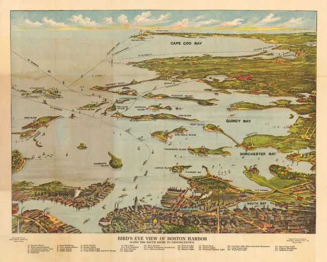
"Bird's Eye View of Boston Harbor Along the South Shore to Provincetown",

Subject: Boston, Massachusetts

Period: 1920 (dated)

Publication:

Color: Printed Color

Size:
19 x 14 inches
48.3 x 35.6 cm
Download High Resolution Image
(or just click on image to launch the Zoom viewer)

Nice bird's-eye map produced for the tourist trade. The attractively colored map folds into paper covers with title "Bird's Eye View of Boston Harbor in colors Along the South Shore to Plymouth Cape Cod Canal and Provincetown Showing all Steamboat Routes. Price 10 cents." The map extends from South Bay all the way to Cape Cod Bay and Provincetown. At the bottom is a numerical key naming and locating 25 landmarks and lighthouses. The map names East Boston, Dorchester Bay, Quincy Bay, Governor's Island, Peddock's Island, Deer Island, Nantasket Beach, Duxbury, Jerusalem, and much more. Numerous ferry and ship routes are shown. The map was printed by either the collotype or color gravure method by the Federal Engraving Co., Boston. Published by The Union News Company.

References:

Condition: B

Covers with a little soiling and one misfold. The map has a hint of marginal toning at lower right and more where the map lays against the brown paper covers, else very good to fine.

Estimate: $80 - $100

Sold for: $190

Closed on 3/1/2006

Archived