Catalog Archive
Auction 114, Lot 139

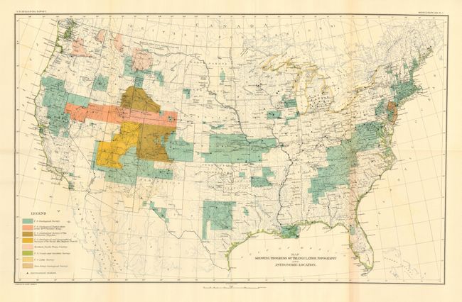
"Map Showing Progress of Triangulation Topography and Astronomical Location", U.S. Geological Survey (USGS)

Subject: United States

Period: 1893 (published)

Publication:

Color: Printed Color

Size:
28 x 17.5 inches
71.1 x 44.5 cm
Download High Resolution Image
(or just click on image to launch the Zoom viewer)

Very detailed and finely colored map showing survey progress throughout the United States. Colored legend locates the surveys by the U.S. Geological Survey, U.S. Geological Exploration (King), U.S. Geological Survey of the Territories (Hayden), U.S. Geological and Geographical Surveys of the Rocky Mtn. Region (Powell), the Northern Pacific Trans Survey, U.S. Coast and Geodetic Survey, U.S. Lake Survey, and the New Jersey Geological Survey. Also locates all astronomical stations. A remarkable map that summarizes the surveys completed and in progress. The map is included in the original monograph by Henry Gannett. "A Manual of Topographic Methods," hardbound in brown cloth (9.3 x 12") 300 pages, numerous tables and drawings, 13 full-page colored maps including 3 of Grand Canyon interest.

References:

Condition: A

Map is folding, as issued and fits into back cover pocket. Map is near mint less one fold with toning and short split. Covers with some rubbing to spine and short splits at top. Contents very good.

Estimate: $70 - $100

Sold for: $300

Closed on 3/1/2006

Archived